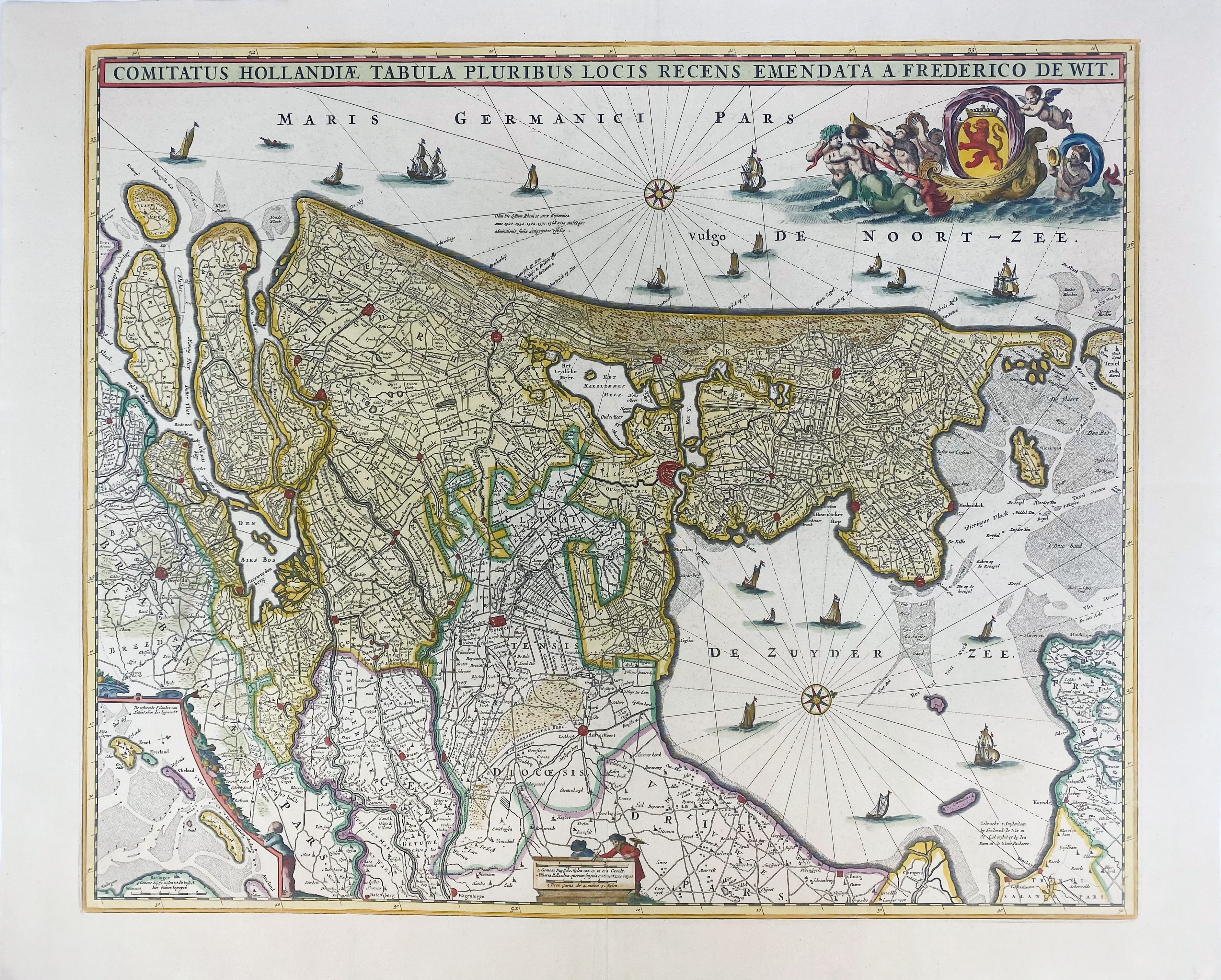
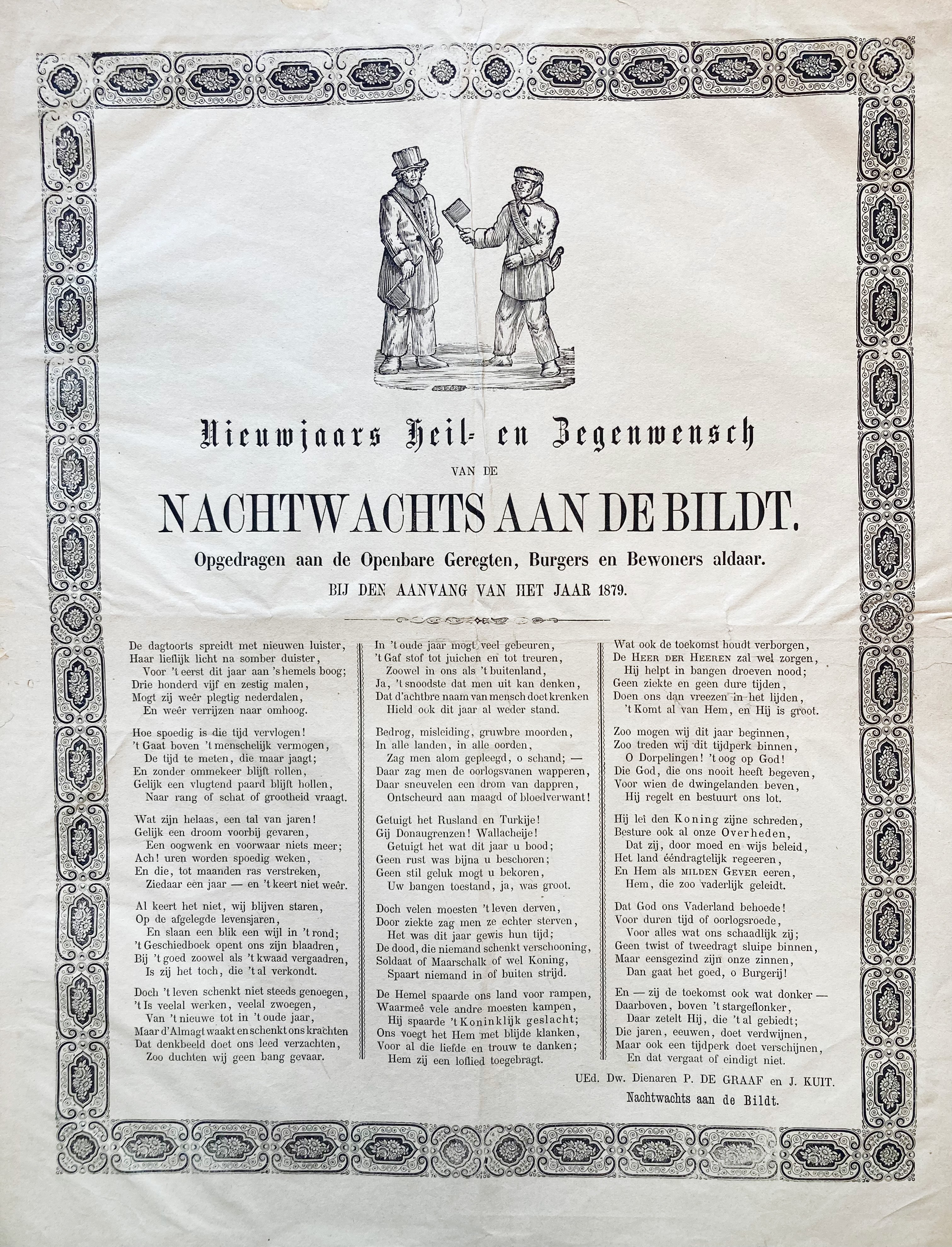
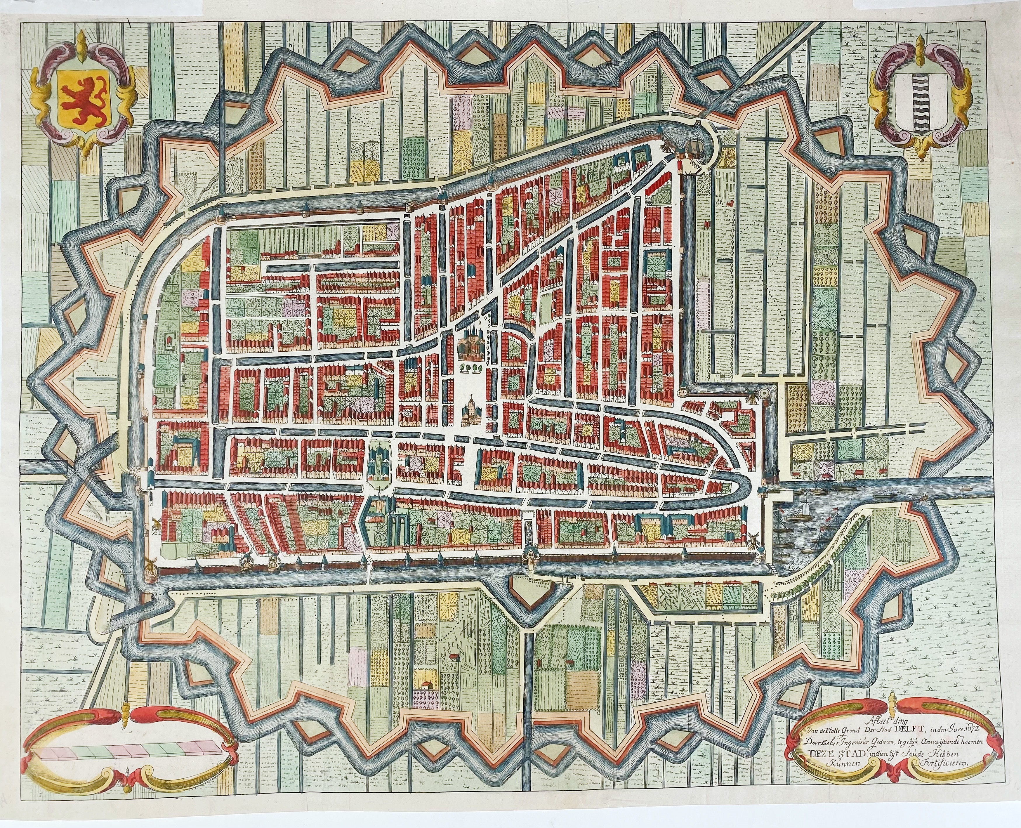
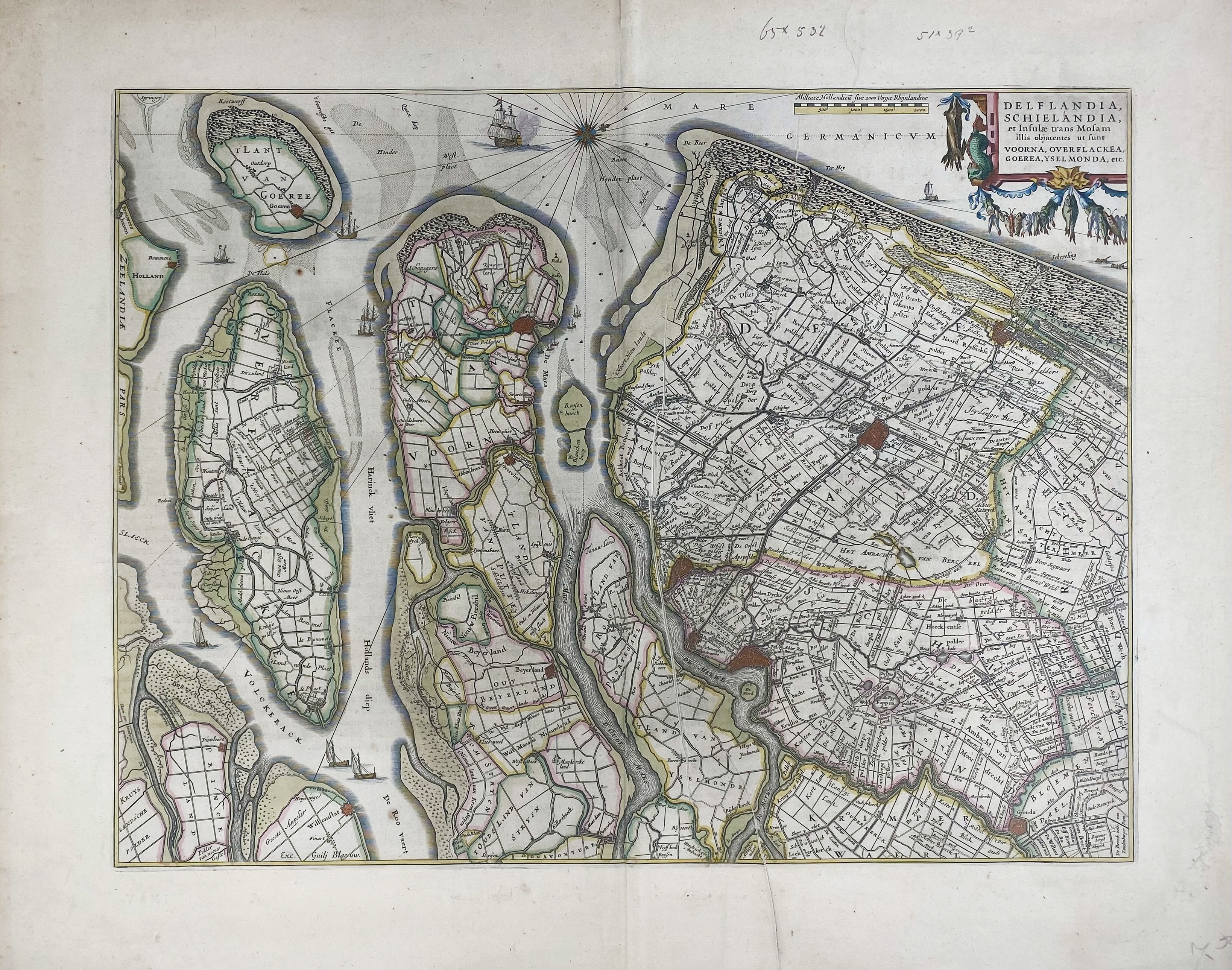
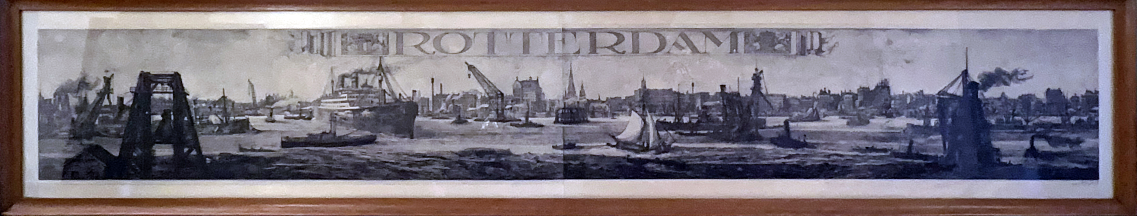
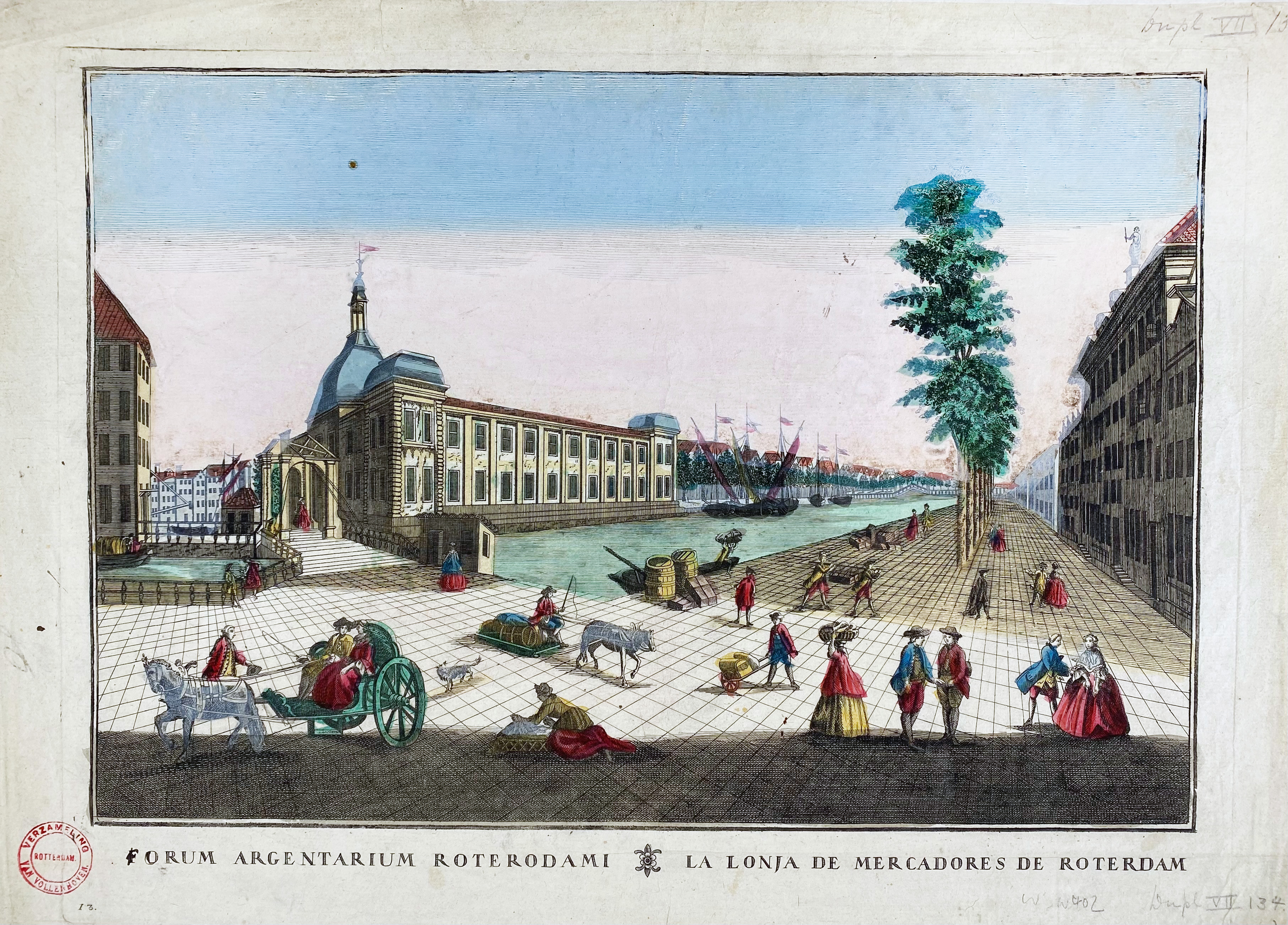
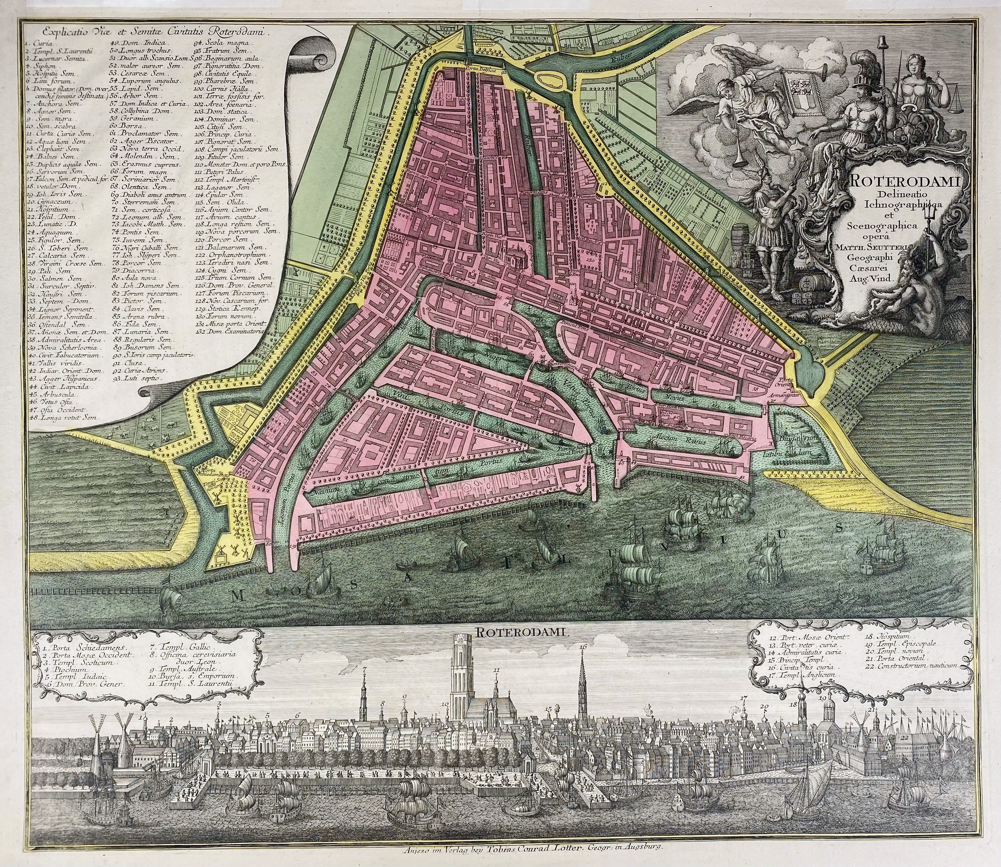
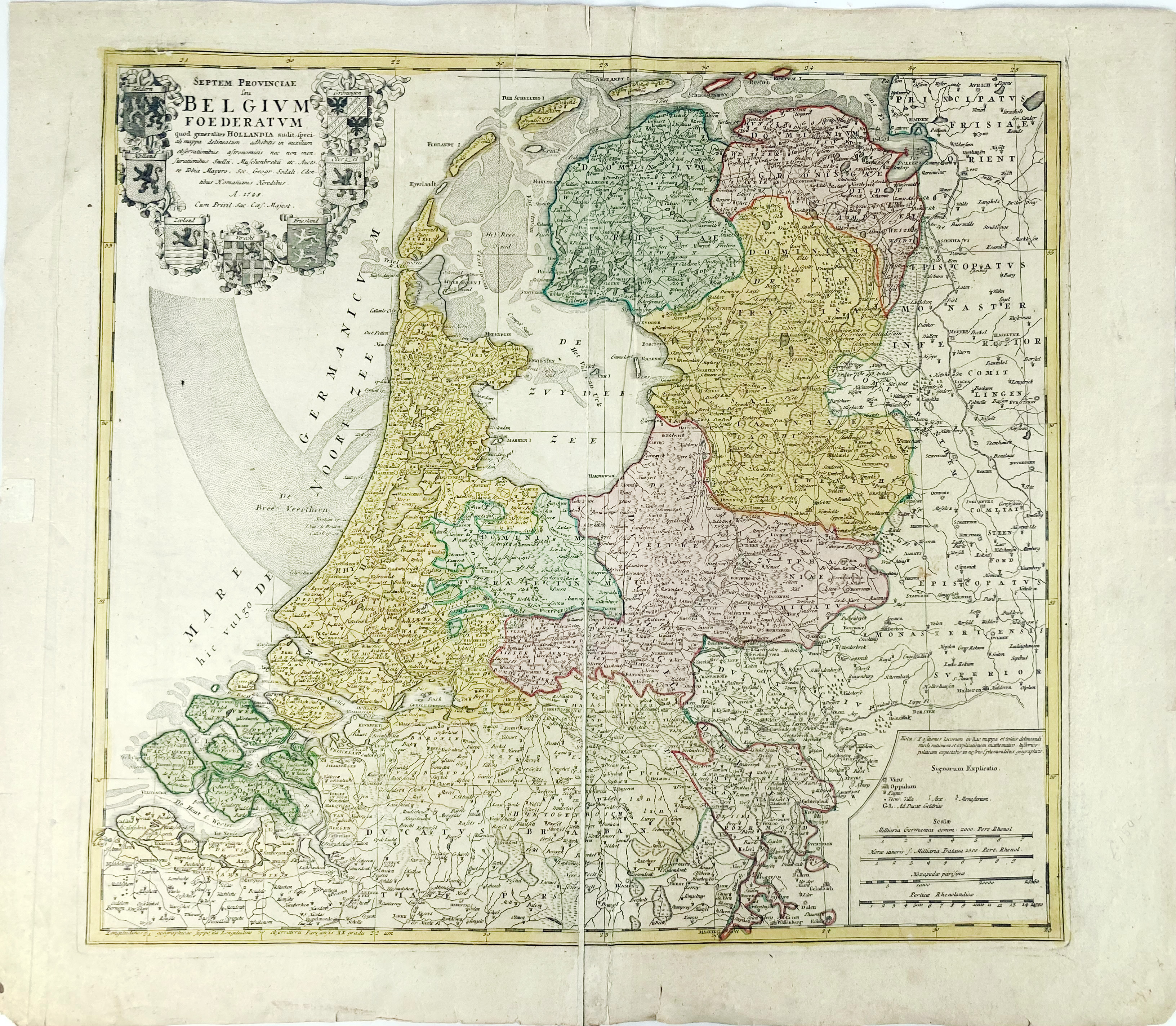
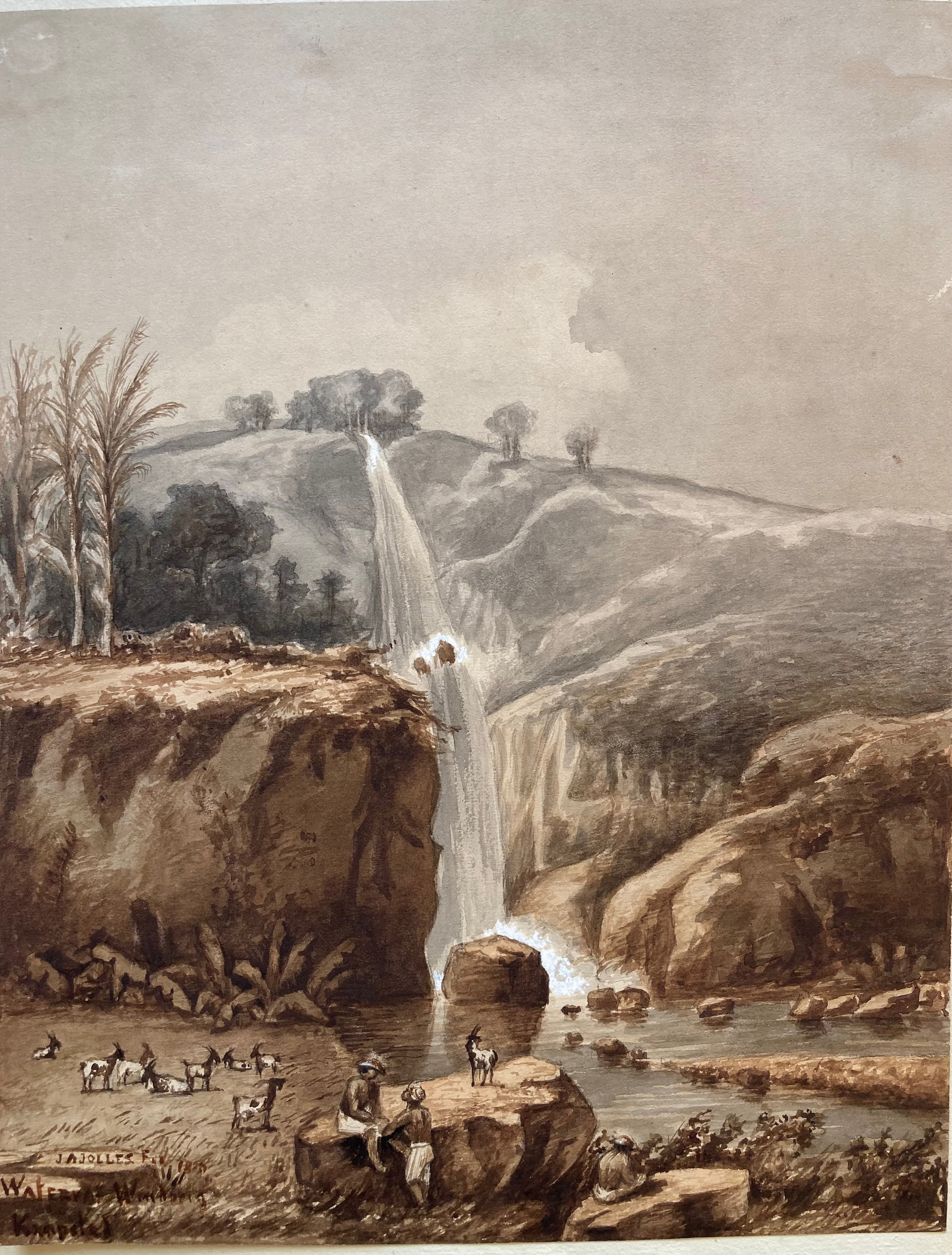
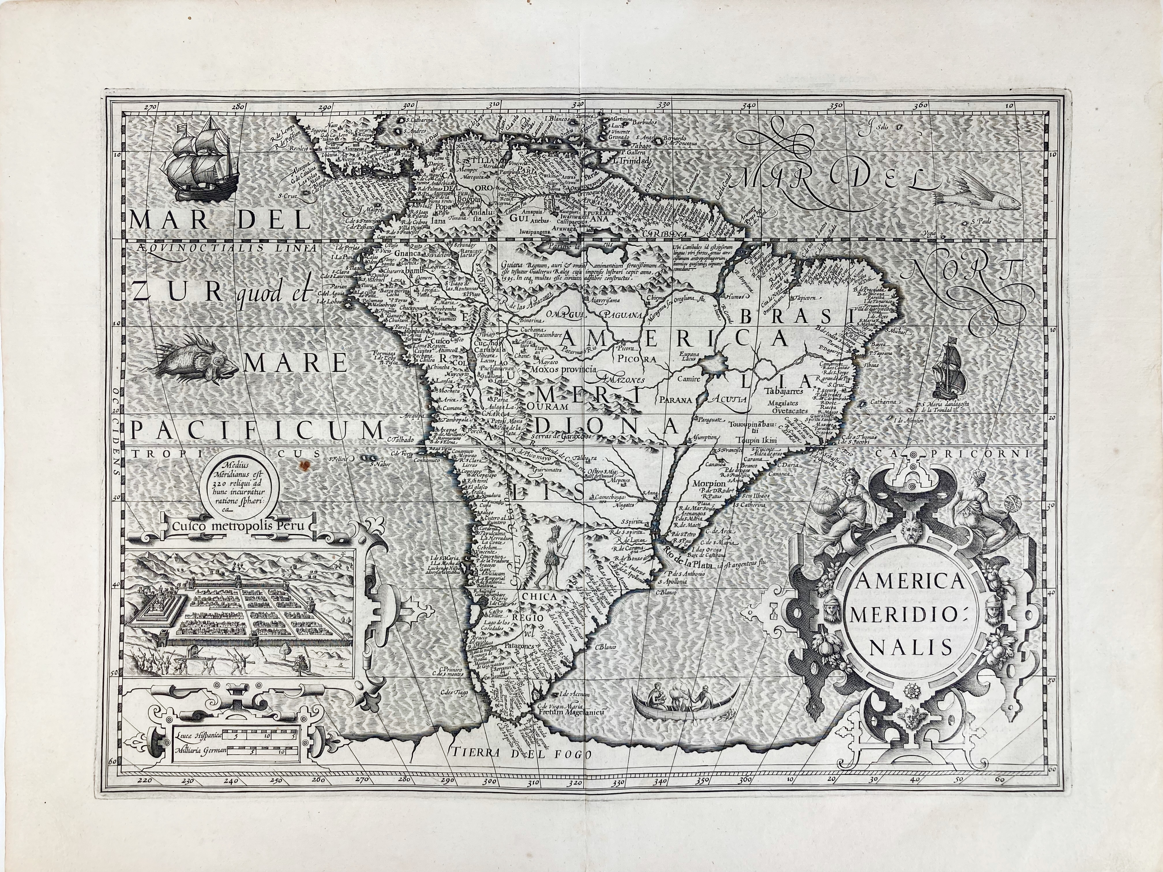
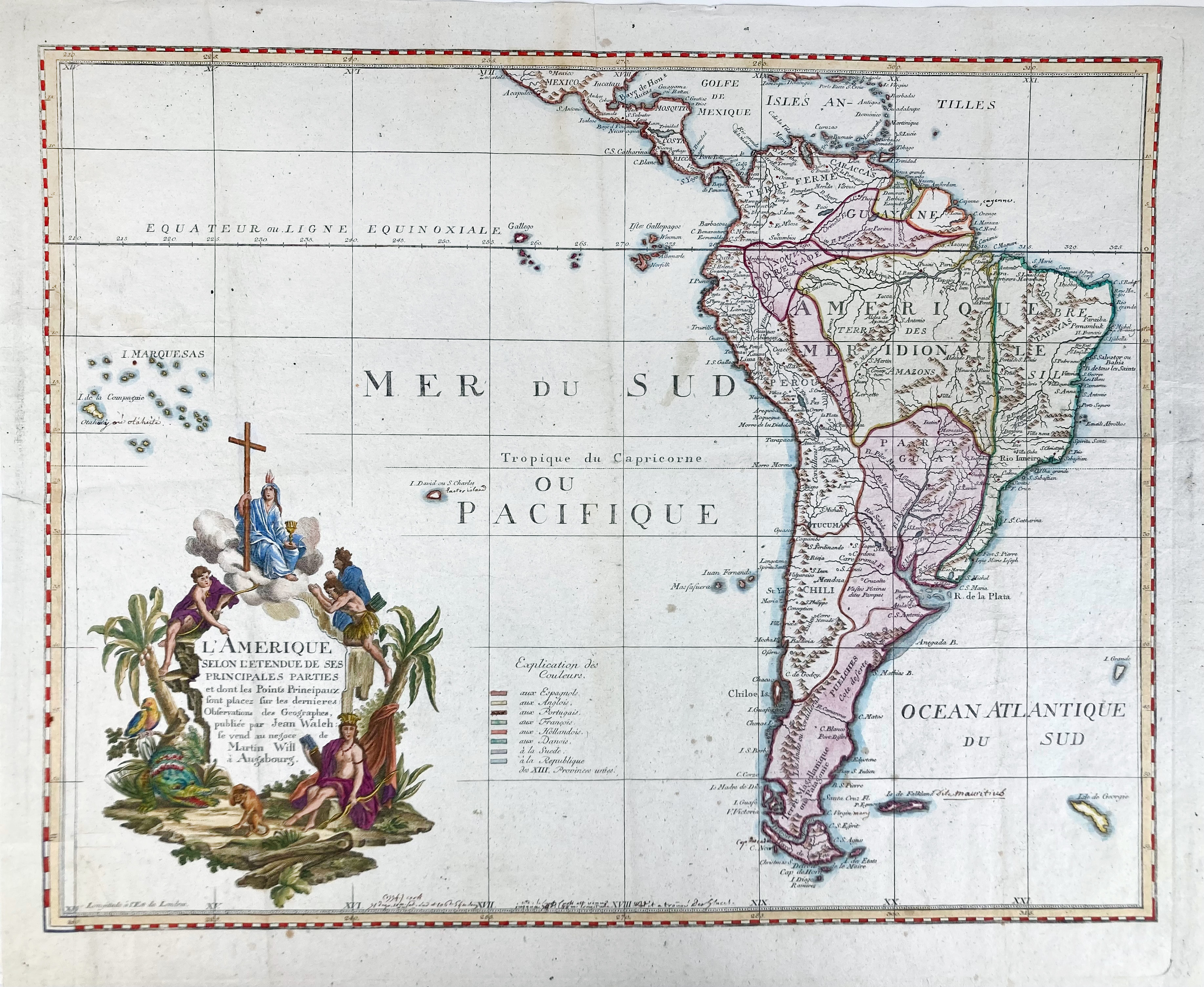
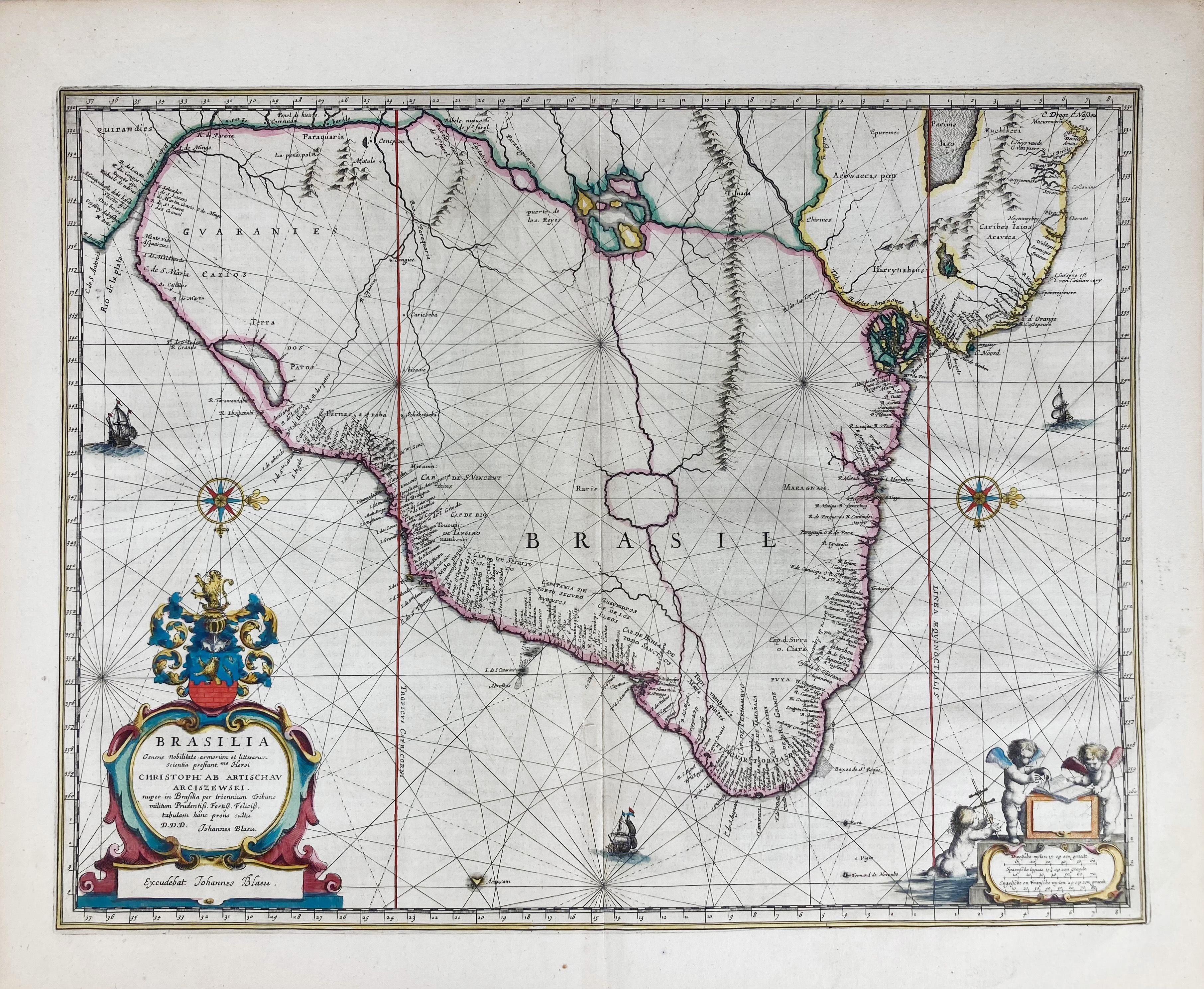
AFRICA - ASIA - EASTERN HEMISPHERE - EGYPT/HOLY LAND - MEDITERRANEAN. Collection of 5 woodcut maps by (after?) P. Plancius (probably) from a 16th c. edition of H. Bünting's 'Itinerarium Sacrae Scripturae'. Each c. 160 x 250 mm. All hinged to a paper mount. - In very good condition.
€ 400
AFRICA -- "AFRICA ex magna orbis terre descriptione Gerardi Mercatoris desumpta, studio et industria G.M. Iunioris". (Duisburg, Mercator Heirs, 1595). Engr. map w. cartouche in beautiful handcolouring. 380 x 470 mm. (Professionally remargined).
€ 500
AFRICA -- "CARTE PARTICULIERE DE L'EGYPTE, de la Nubie et de l'Abyssinie". - "CARTE DE LA BARBARIE, Nigritte et de la Guinée avec les pys voisins (…)". - (Paris, G. de l'Isle, 1732). 2 plain engr. maps. 405 x 525 mm. (Both w. some light staining to lower right margin). -- And 3 o. (5).
€ 120
AMERICA -- "AMERICA NOVITER DELINEATA". (Paris, J. Boisseau, c. 1643). Plain engr. map by Hugues Picart after J. Hondius, w. 2 inset maps: Antarctic regions and Groenland. 385 x 510 mm. (A bit age-toned, but in v.g. condition).
€ 1500
AMERICA -- "AMERICA SIVE INDIA NOVA". (Duisburg, Mercator Heirs, 1595). Engr. circular map of the western hemisphere in beautiful handcolouring, surrounded by 3 inset circular maps of Cuba, Haiti and the Gulf of Mexico in each corner, the title set in the fourth. 370 x 460 mm. (Professionally remargined).
AMERICA -- "AMERICAE PARS MAGIS COGNITA". (Frankfurt), Th. de Bry, 1624. Engr. map of the Americas w. elaborate cartouches, coats of arms, 2 compass roses, and 2 insets. (Upper margin partly cut off (w. loss of part of the decorative border), a strip at the foot of c. 10 mm across the entire width of the image is missing unfortunately, browned).
€ 200
AMERICA -- "LA FLORIDA - GUASTECAN - PERUVIAE AURIFERAE REGIONIS TYPUS". (Antwerp, A. Ortelius, 1584). Engr. map divided in 3 sections, cold. by hand. 335 x 470 mm. (A bit age-toned, 2 splits in margin, of which 1 closed, foot of central fold split (not running into image)).
€ 180
AMERICA -- POPPLE -- ("MAP OF THE BRITISH EMPIRE in America with the French and Spanish Settlements Adjacent Therto, A"). London, W.H. Toms, 1733. 3 engr. maps (of 20) by H. Popple, cold. by hand. c. 700 x 505 (2x) and 500 x 315 mm. (Colouring of the maps is different, section 19 w. some marginal wear & tear (not affecting the image)).
€ 300
ARMILLARY SPHERE. France (?), 19th c. French wooden heliocentric sphere. Ø 285, 460 mm (h), incl. black wooden pedestal. (The pedestal shows signs of worming, the sphere itself a bit darkened, some of the gilding of the sun is worn, but altog. in good condition).
€ 1600
ASIA -- "ASIA ex magna orbis terræ descriptione Gerardi Mercatoris desumta, studio et industria G.M. Iunioris". (Duisburg, Mercator Heirs, 1595). Engr. map w. cartouche in beautiful handcolouring. 375 x 465 mm. (Professionally remargined).
€ 800
ASIA -- "CHINAE, olim Sinarum regionis, nova descriptio." (Antw., Ortelius, 1595). Engr. map w. 3 elaborate cartouches containing title, printing information and the scale bar, map decorated with animals, the Great Wall, a Tartar encampment, ships and sailing carts. 370 x 470 mm.
ASIA -- "DER HOLLAENDISCH-OSTINDIANISCHEN COMPAGNIE Weltberühmte Haupt- Handels und Niederlags-Stadt Batavia (...)." Nürnberg, Homann heirs, 1733. Partially handcold. engr. plan, w. below a profile of the city & 3 small inset views. 472 x 555 mm. Framed, glazed, & under passepartout. (Closed tear in the center, unispected out of frame).
ASIA -- "INDIAE ORIENTALIS et Insularum Antiqua et nova Descriptio". (1697). Plain engr. map by Ph. Clüver. 220 x 265 mm. -- "DE LANDVOOGDIJ DER MOLUCCOS met de aangrenzende Eijlanden". (c. 1725). Plain engr. map w. large inset in right upper corner. 465 x 588 mm. (Margins a bit creased). Taken from Fr. Valentyn's 'Oud en nieuw Oost-Indiën'. -- "DE RIEVIER VAN SURATTA". (c. 1725). Plain engr. map from Valentyn. 305 x 390 mm. Taken from Fr. Valentyn's 'Oud en nieuw Oost-Indiën'. -- "DESCRIPTIO MALACCAE". (c. 1606). Plain engr. map from Bertius' 'Tabularum Geographicum Contractarum'. 87 x 125 mm. -- And 4 o. maps. (8).
ASIA -- "INDIAE ORIENTALIS Nova Descriptio". Amst., J. Janssonius, (1633 or later). Engr. cont. handcold. map, w. 3 dec. cartouches, a ship battle and compass roses. (Laid down, traces of former framing, sl. age-toned).
ASIA -- "INSULAE INDIAE ORIENTALIS praecipuae, in quibus Moluccae celeberrimae sunt." Amst., J. Hondius, (1606 or later). Engr. cont. handcold. map, w. 3 dec. cartouches, a ship battle and compass roses. (Repaired on v°, traces of former framing, a bit browned).
€ 600
ASIA -- "MAGNI MOGOLIS IMPERIUM". Amst., P. Schenk & G. Valk, (c. 1700). Cold. engr. map w. 2 cartouches 365 x 485 mm. -- Added: "TAB. XIII. ASIAE Scythiam Extra Imaum ac Sericam". (Duisburg, Mercator, 1698). Engr. map after Ptolemaeus of the Himalayas, Tajikistan, Kyrgyzstan and Western China. 345 x 403 mm. -- And 3 o., incl. a leaf taken from Sylvanus "Octava Asiae Tabula", ed. 1511. (5).
ASIA -- "NIEUWE KAART van de Filippynsche, Ladrones, Moluccos of Specery Eilanden, als mede Celebes, etc." 285 x 335 mm. - "NIEUWE KAART v.d. Sundasche Eilanden als Borneo, Sumatra en Groot Iava &c." 280 x 365 mm. - Amst., I Tirion, (c. 1750). 2 engr. handcold. maps. Framed, glazed & under passepartout. (Uninspected out of frame).
€ 150
ASIA -- SRI LANKA/CEYLON -- "INSULA CEILON olim Taprobana Incolis Tenarisin et Lankawn". Amst., N. Visscher, (c. 1690). Engr. handcold. map w. large cartouche. 495 x 590 mm. Framed, glazed & under passepartout. (Significantly browned, uninspected out of frame).
ASIA -- "TABULA ASIAE II". (c. 1571). Plain woodcut map of Asia Minor and the Caucasus region by S. Munster, from 'Strabonis rerum geographicarum libri'. 340 x 250 mm. (Some spots in upper margin, sl. age-toned, traces of former hinging). -- "CONSTANTINOPOLITANAE urbis effigies, quam hodie sub Turcæ inhabitatione habet." (Basel, c. 1552).Plain woodcut view of Constantinople including numerous ships in the harbor and a town plan, from Munster's 'Cosmographia'. 202 x 380 mm. (Margins skilfully restored). -- (2).
€ 130
ASIA -- "TARTARIA". (Amst.), J. Hondius, (1606). Engr. map of Central Asia, Siberia and China in cont. colouring. 345 x 495 mm. (Some small holes in image in places, a bit soiled/browned, small rep. on v°, but very reasonable).
CANADA -- "CARTE DU CANADA ou de la Nouvelle France, & des découvertes qui y ont été faites". (Paris, c. 1730). Engr. map by H. Chatelain. 405 x 520 mm. (Small repair to right lower corner).
€ 100
CELESTIAL CHARTS -- ROYER -- SOUTHERN CELESTIAL HEMISPHERE. (Paris, J.B. Coignard, 1679). Pair of 2 circular complementary charts printed on rectangular sheets of paper depicting the Southern celestial hemisphere, one chart more 'magnified' than the other, both cold. by hand. Ø 390 and 373 mm. (Some tiny inconspicuous holes in image in places, top and bottom margins of the largest chart short, but in good condition).
€ 2000
DUMONT D'URVILLE -- "SAINT CROIX de Ténériffe" - "VUE de Saint Denis [Réunion]" - "VUE de Sandy-Bay" [Ascension] - "VUE de Jame's-Town" [St. Helena]. (Paris), J. Tastu, n.d. (1830). 4 lithogr., cold. by hand, by Guérard/Adam & St. Aulaire after De Sainson. 190 x 370 mm (image size) w. ample margins. (A bit age-toned, outer margins frayed/torn in places, but in good condition).
EASTERN EUROPE -- POLAND -- BAZEWICZ, J(ósef) M(icha). "Polska W. Trzech Zaborach G. Tranicach Przedrozbiorowwch W 1770 R. Oraz W Innych Wazniejszych Okresach Historycznych". Warsaw, (1921). Decorative cold. lithogr. map of Poland decorated with the coats of arms of Polish voivodeships and military institutions, four inset maps showing Poland's territorial evolution. 695 x 990 mm (paper size). (A bit age-toned, else fine).
€ 240
EGYPT -- (PYRAMIDS AND SPHYNX OF GIZA). (1698). Engr. by J. Luyken. 286 x 388 mm. Numbered in plate '85' top right. Framed, glazed and under passepartout.
€ 70
EUROPE -- "EUROPA ad magnae Europae Gerardi Mercatoris P. imitationem (…)". (Duisburg, Mercator Heirs, 1595). Engr. map w. cartouche in beautiful handcolouring. 375 x 460 mm. (Professionally remargined, some loss of text ("Duysburgi...") in lower right corner).
FRANCE -- CHAPUY, (N.-M.-J.). Vue générale de Lyon. Vue prise au dessus de la Place de Brosses, à la Guillotière. Paris, Lemière, (c. 1840). Tinted lithogr. by Ch. Fichot after Chapuy. 390 x 580 mm.
GERMANY -- COLLECTION of 63 views of German towns and scapes. All 19th c. 26 lithogr. (4 in colour); 13 plain aquatints, 23 steel-engr. and 1 wood-engr. All c. 100 x 160 mm. - Including a series of 14 lithogr. views of Koblenz, published by Heinrich Müller.
GERMANY -- MÜNDEN -- COLLECTION of 42 views of Münden, of which 14 cold. by hand. First h. 19th c. Diff. sizes. (A bit browned/foxed here and there, traces of former framing, but in v.g. condition).
GREAT BRITAIN -- ("BRITANNIA INSULA quae duo regna continent Angliam et Scotiam cum Hibernia"). Roma, G. Orlandi, 1602. Engr. map of the British Isles with the North being at the top. 491 x 354 mm. (Faint marg. stain, sl. browned/foxed).
GREAT BRITAIN -- "BRITANNIAE INSULAE quae nunc Angliae et Scotiae regna continet cum Hibernia adiacente nova descriptio". Roma, G. Orlandi, 1602. Engr. map with the Sebastiano de Re da Chioggia imprint, orientated to the west with Ireland in the north, two panels with Latin text describe Ireland and Britain and a third one containing the title. 397 x 543 mm. (Margins cut short, in upper left margin touching the plate edge, margins a bit frayed in places and w. sm. tears, sl. browned/dust-soiled).
€ 700
HARBOUR VIEWS -- "GEZICHT DER STAD TRIPOLI van de Rhede te zien". 1818. Drawing in black ink and colour wash, signed in lower right corner E. du Fes 'Luit(ena)nt ter zee'. 263 x 353 mm. Laid down on cardboard mount, traces of previous framing. Harbour view of Tripoli. W. annotation on the back side: "Het eskader onder Vice-admiraal Van Braam. Admiraalschip: het linieschip Koning Willem I". -- Added: (Harbour view of Medemblik). (c. 1833?). Drawing in Indian ink and black wash. Monogrammed in the right lower corner P.A. v. R(ees). 42 x 234 mm. Laid down on mount. Small, but attractive view of Medemblik. -- And 2 similar, of which 1 a drawn view of 'Het Fort Decima op het eiland Formosa', c. 1820 (by Hubert Vos?). (3).
ITALY -- VENICE -- "IL MOLO/le Môle" - "PIAZZA DI S. MARCO/Place St. Marc" - 'IL PONTE DI RIALTO/Le Pont de Rialto" - Venice, G. Kier, n.d. (c. 1859). 3 lithogr. town views of Venice, cold. by hand and 'gommé'. 170 x 287 mm (image size) each, captioned on the stones. (Margins a bit foxed w. small splits and soiled in places, but images bright and lively). - From Marco Moro's 'Album delle principali vedute di Venezia'.
ITALY -- VENICE -- "PONTE DI RIALTO/Le Pont de Rialto" - "PIAZZA DI S. MARCO/Place de S. Marc" - "PONTE DELLA PAGLIA, E PRIGIONI/Pont de la Paille, et Prisons" - "PIAZZETTA DI S. MARCO/Petite Place de S. Marc" -- "J.R. ARSENALE/J.R. Arsenal" - (Venice), Gio. Gallo, n.d. (c. 1830). 5 fine plain aquatint town views of Venice by A. Lazzari (from a series of 12: 'Vedute principali di Venezia'), captioned in the plates. (In very good condition, but w. some foxing to outer blank margins and some marginal splits (not affecting images)).
ITALY -- (VIEW ON MOUNT VESUVIUS and the Bay of Naples). (c. 1860). Lithogr. w. heavy gouache colouring. 425 x 620 mm. Hinged on cardboard. (W. sm. marg. tear, minor chip to upper right corner and sm. central damp stain, sl. age-toned).
ITALY -- "VÜE DES RESTES d'un Temple de Venus dans l'Isle de Nisida près de Pouzzol au Golfe de Naples". Paris, 1761. Plain engr. view by N. le Mire. 355 x 460 mm. (Blank margins a bit dam., but not affecting image). -- Added: "VEDUTA DELL'ARCO TRIONFALE DI CONSTANTINO (…)/Vüe de l'Arc Triomphal de Constantin (…)". N.pl., n.d. (c. 1750). Engr. view. 187 x 240 mm. -- "VEDUTA DELL'AVANZI DEL FORO TRAJANO, e Colon[n]a (…)/Vüe des Restes du Forum Trajane (…)". N.pl., n.d. (c. 1750). Engr. view by G. Acquaroni. 190 x 240 mm. -- "ANFITEATRO FLAVIO detto il Coloseo" - "PIAZZA di S. Pietro" - 2 fine aquatint views by Ign. Gigli. 158 x 195 mm. -- And 28 o. (smaller) views of Italian towns and scapes. (33).
LOW COUNTRIES -- "AFSTANDS-WIJZER v.h. Koningrijk der Nederlanden vervaardigd op het Topographisch bureau v.h. Ministerie v. Oorlog op de schaal v. 1:200.000." 1862. Lithogr. map, mounted in 36 parts on 6 sections of fold. linen. Each section c. 560 x 725 mm. In slipcase. (Some annotations and lines in blue pencil, slipcase sl. worn).
LOW COUNTRIES -- "ALGEMEENE KAART van het Koningryk der Nederlanden, zynde, voor zoo verre de schaal zulks gedoogt, eene itineraire van dezen Staat; uit de laatste naauwkeurige driehoeks metingen en de beste topographische stukken zamengesteld." 1816. Large engr. map by C. Müller, cold. in outlines, mounted in 42 sections on linen. 1370 x 970 mm. In cont. marbled brds. chemise & slipcase.
LOW COUNTRIES -- AMERSFOORT -- "AMISFURTUM." (Amst., Blaeu, 1652). Engr. plain bird's eye plan w. cartouche w. 2 coats of arms of Amersfoort. 417 x 520 mm. (Margins a bit dustsoiled, a few sm. marg. tears).
€ 140
LOW COUNTRIES -- AMERSFOORT -- "AMISFURTUM." (Amst., Blaeu, 1652). Engr. plain bird's eye plan w. cartouche w. 2 coats of arms of Amersfoort, cold. by hand. 417 x 520 mm. Dutch text on v°. -- Added: "ZIRIZEA [Zierikzee]". (Amst., Blaeu, 1652). Engr. plain bird's eye plan w. cartouche w. 2 coats of arms and 2 cartouches, cold. by hand. 420 x 530 mm. Dutch text on v°. -- And 2 o. bird's eye perspective plans, 1 cold. (4).
LOW COUNTRIES -- AMERSFOORT -- "AMORFORTIA Dioecesis Ultraiectensis Oppidum amœnitate loci solique fertilitate admodum insigne". (Cologne, Braun & Hogenberg, c. 1593). Plain engr. plan of the city in bird's eye perspective (250 x 375 mm), on top of a view of the city from the North (115 x 395 mm). Total image size: 365 x 395 mm. Text in Latin on v°. (Remnants of former hinges on v°, sm. tear in middle of fold, sl. browned).
LOW COUNTRIES -- AMSTERDAM -- "AMSTEL-GESICHIES". (c. 1680). 4 (of 6) etchings (nrs. 1, 4, 5, 6) by A. Bloteling after Jacob v. Ruisdael. Each print 164 x 215 mm. -- "EEN ANDER GESICHT van 't landts magazyn". (1663). Handcold. engr. from O. Dapper, Historische beschryving der Stadt Amsterdam. 185 x 290 mm. (Sl. age-toned). -- And 3 o. (8).
LOW COUNTRIES -- AMSTERDAM -- "AMSTELODAMI veteris et novissimi delineatio per Joannem de Ram." Amst., J. de Ram, (c. 1693). Engr. bird's eye plan w. profile below and 2 coats of arms. 480 x 570 mm. (Margins cut short, sl. age-toned).
€ 1000
LOW COUNTRIES -- AMSTERDAM -- "AMSTERDAM". (Frankfurt a/M., M. Merian, c. 1659). Handcold. engr. profile view of the city on 2 conjoined plates, w. 2 coats of arms and w. key to locations in German. 200 x 715 mm. (Sl. age-toned, traces of former hinging).
LOW COUNTRIES -- AMSTERDAM -- "CARTE PARTICULIERE D'AMSTELLAND, ou Les environs d'Amsteldam, Muyden, Weesp, Naarden &c. Particuliere kaart van Amstellandt of het omleggende van Amsteldam, Muyden, Weesp, Naarden &c. Amst., I. Covens & C. Mortier, 1749. Engr. cold. map on 2 joined sheets by I. Condet. 485 x 630 mm. Framed, glazed & under passepartout. (Sl. age-toned, uninspected out of frame).
LOW COUNTRIES -- AMSTERDAM -- "HET BLOCQUEEREN VAN AMSTERDAM, door de troepen van Willem de Tweede, prins van Oranje, van den 30. July, tot den 4 Augusty des Jaars 1650." (1730). Engr. map, cold. in outlines. 270 x 400 mm. -- "AMSTERDAM vertoonde zigh aldus inden jare 1500". (1693). Handcold. engr. plan. 263 x 340 mm. -- "AMSTELREDAM". (1648). Handcold. engr. plan. 240 x 262 mm. (Sl. browned). -- And 1 o. on A. (4). (All w. traces of former hinging).
LOW COUNTRIES -- AMSTERDAM -- "NIEUWE EN ZEER NAEUKEURIGE kaerte der Stadt Amsterdam met alle haere gebouwen Waterkeeringen en wyken der burger compagnien". Amst., A. & H. de Leth, (c. 1730). Handcold. engr. plan. 440 x 527 mm. (Margins skilfully restored in a few places, traces of former hinging).
LOW COUNTRIES -- "BELGII SIVE GERMANIAE Inferioris accuratissima tabula". Amst., H. Hondius, 1631. Engr. map in cont. handcolouring, w. 3 cartouches, ships and a compass rose, and a decorative border with city plans and views i.a. Leuven, Luxemburg, Ghent, Arras, Middelburg, Zutphen, Antwerp, Mechelen, Deventer, & costumed figures in oval frames. 482 x 600 mm. Framed, glazed & under passepartout. (Uninspected out of frame, a bit browned).
€ 1200
LOW COUNTRIES -- BREUKELEN -- "VEUES DE GUNTERSTEIN. Dediees A Madame de Gunterstein et de Thienhoven". Amst., N. Visscher (II)/J. Le Moine de l'Espine, n.d. (between 1680 and 1699). 16 engr. views, incl. ti.-plate and a series of 15 views by J. Mulder of the castle and gardens, captioned in the plates, printed (uncut!) on 4 lge-fol. sheets.
LOW COUNTRIES -- "CAERTE vanden Lande ende Graefschappe van Hollandt (…)". 1589 (=Amst., c. 1612). Engr. map of Holland by I.P. Saenredam, cold. by hand. 260 x 370 mm. (Outer right and left margin cut close to image border, remargined).
LOW COUNTRIES -- COLLECTION of 13 cold./tinted lithogr. town views (Zwolle, Breda, Middelburg, etc.), all publ. mid 19th c. Each c. 140 x 200 mm. -- Added: a collection of 38 wood-engr. views of Dutch towns, all published c. 1847. Diff. sizes, tipped in on mounts. -- And 3 o. (54).
€ 90
LOW COUNTRIES -- COLLECTION of 245 engraved views on Dutch towns, villages and landmarks, primarily by A. Rademaker and H. Spilman. 18th c. 81 x 112 mm, some larger, some cold.
LOW COUNTRIES -- "COMITATUS HOLLANDIAE tabula pluribus locis recens emendata a F. de Wit." Amst., F. de Wit, (c. 16905). Engr. map in cont. handcolouring w. cartouche, small inset map of the Wadden Islands, 2 compass roses and many ships. 455 x 550 mm.
LOW COUNTRIES -- DE BILT -- "NIEUWJAARS HEIL- EN ZEGENWENSCH van de nachtwachts aan De Bildt (…) bij den aanvang van het jaar 1879". -- Added: 3 similar for the years 1891, 1892 and 1893. -- Utr., Kemink & Zn. Tog. 4 broadsides w. letterpress text within decorative border. (Some marg. repairs to v°., but in v.g. condition).
€ 80
LOW COUNTRIES -- DELFT -- "AFBEELDING VAN DE PLATTE GROND DER STAD DELFT, in den Jare 1672 : Door Zeker Ingenieur Gedaan, tegelijk Aanwijzende hoemen Deze Stad indien tijt Soude Hebben Kunnen Fortificeeren." (Delft, 1729). Handcold. engr. plan of the city tog. w. (never realised) fortification. 420 x 525 mm. (Traces of former hinging).
LOW COUNTRIES -- DELFT -- "DELFLANDIA, SCHIELANDIA, et insulæ trans Mosam illis objacentes ut sunt Voorna, Overflackea, Goerea, Yselmonda, etc." (Amst.), W.J. Blaeu, (1662). Cont. engr. cold. map. 385 x 502 mm. (With some sharp creases). -- "NIEUWE KAART VAN DELFTLAND". Delft, I. Tirion, (1753). Cont. engr. cold. map. 340 x 387 mm. (Ample margins, but w. tiny tears and some marg. foxing, sm. piece of blank lower left corner torn off). -- (2).
LOW COUNTRIES -- DELFT -- "HOOGE HEEMRAEDSCHAP van Delflant, 't". N.pl., 1712. Engr. plain general map of polder district 'Delfland' by Van Anse, Doesburgh, (a.o.) after N. & J. Kruikius w. engr. title in top border and w. 5 fine engr. coats of arms by P. Haringh on each outer side. 520 x 580 mm. (Cut out close to/on plate edges and laid down on paper).
LOW COUNTRIES -- DEVENTER -- "DAVENTRIA vernacule Deventer". (Amst.), J. Blaeu, 1650). Fine engr. plan of the city in bird's eye perspective, cold. by hand, w. 2 coats of arms and dedic. cartouche. 420 x 525 mm. Dutch text on v°. (Tear in upper blank margin closed). -- Added: "ZUTPHEN". (Cologne, Braun & Hogenberg, c. 1588). Engr. plan of the city in bird's eye view in cont. colouring. 317 x 422 mm. Latin text on v°. -- (2).
LOW COUNTRIES -- DEVENTER -- "GEZICHT OP DEVENTER/Vue à Deventer". Den Haag, Wed. E. Spanier & Zn., n.d. (c. 1860). Cold. lithogr. view of the city w. the river IJssel in the foreground. 246 x 340. (Blank margin gone for about 4 cm. in upper right corner). -- Added: 4 tinted lithogr. views of Deventer by Jan Striening. Amst., Amand Lith., 1876. 137 x 210 mm each. All hinged to mounts. (1 a bit dam.). -- And 1 o. of D. (6).
LOW COUNTRIES -- "DORDRECHT". (Amst., Blaeu, 1652). Handcold. engr. bird's eye plan, coat of arms in both upper corners. 413 x 520 mm. (Central fold split at the bottom, margins faintly stained, sl. yellowed, traces of former hinging). -- Added: PASCAERT van 't Eylandt Roosenburg door de Oude en Nieuwe Maes tot aen Dordrecht en van daer door de Kill tot aen Oudehoornsluys (…). Amst., J. v. Keulen, (c. 1685). Engr. handcold. chart. 490 x 545 mm. (Some light foxing, traces of former hinging). -- (2).
LOW COUNTRIES -- "FORUM ARGENTARIUM ROTERODAMI". (Augsb., Probst, c. 1790). Engr. handcold. optical view of the Rotterdam Exchange. 275 x 400 mm. Sixt v. Kapff K 238. -- "HET STADS NIEUWE WERK-HUIS uit de Plantaadje te zien." (Amst./Harlingen), 1787. Engr. view by P. Conradi & V. v.d. Plaats. 280 x 340 mm. -- "DE PLOMPE TOREN, buiten het Bagijnen Waterpoortje, te zien." (c. 1830). Handcold. lithogr. by Houtman. 220 x 260 mm. -- And 3 o. (2 cold.) on Utrecht. (6).
LOW COUNTRIES -- "GEDENK-TEYKENEN, der wonderlyke geschiedenissen, voorgevallen in de Vereende Nederlanden, in 't iaar, 1672". Amst., C. Allardt, n.d. Etching by J. Sorious, cold. by hand. 430 x 524 mm. (Laid down, margins short).
LOW COUNTRIES -- GELDERLAND -- "DUCATUS GELDRIAE nova tabula in Tetrarchias Noviomagi, Arnhemii, Ruremondae ac Zutphaniae Comitatum (…)". (Amst.), J. Ottens, (c. 1720). Engr. map, nicely cold. by hand. 597 x 505 mm.
LOW COUNTRIES -- GELDERLAND -- "DUCATUS GELDRIAE nova tabula in Tetrarchias Noviomagi, Arnhemii, Ruremondae ac Zutphaniae Comitatum (…)". Augsburg, M. Seutter, (c. 1750). Engr. map, nicely cold. by hand. 598 x 515 mm. (Split in left outer margin running into image, but in excellent condition).
LOW COUNTRIES -- "HARLEMUM, Vernacule Haerlem". (Amst.), J. Blaeu, 1646 (=1652). Handcold. engr. bird's eye plan after P. Wils w. 2 coats of arms, and 3 inscribed cartouches. 465 x 570 mm. (Split on bottom of fold repaired on v°, a few tiny marg. tears).
€ 360
LOW COUNTRIES -- "HOLLANDIA COMITATUS". Amst., W. Blaeu, (c. 1645). Engr. handcold. map w. 3 cartouches, coat of arms and inset map of the Wadden Islands. 394 x 526 mm. Framed, glazed and under passepartout. (Uninspected out of frame, image browned).
LOW COUNTRIES -- "HOLLANDIÆ ANTIQUORUM CATTHORUM SEDIS nova descriptio, auctore J. a Daventria". (Antwerp, Ortelius, c. 1598). Engr. map in cont. colouring w. inscribed cartouche, coat of arms of Frisia and scale indicator. 355 x 485 mm. Framed, glazed, & under passepartout. (Uninspected out of frame, a bit browned).
€ 280
LOW COUNTRIES -- "HOLLANDIAE pars septentrionalis, vulgo Westvriesland en 't Noorder Quartier". Amst., J.Janssonius, (c. 1652). Engr. cold. map. 450 x 550 mm. -- (NORTH-HOLLAND). Amst., H. Hondius, (c. 1634). Engr. cold. map. 450 x 550 mm. (Margins short, a few rep. on v°, a bit browned). -- "RHINOLANDIÆ, AMSTELANDIÆ, et circumjacent. aliquot territorioru[m] accurata desc." Amst., H. Hondius, (c. 1634). Engr. cold. map by B.F. van Berckenrode. 455 x 550 mm. (Lower margin rep., margins short/a bit frayed, central fold rep., a bit browned). -- (3).
LOW COUNTRIES -- "HOLLANDT". ("Hollandia quae olim Catthorum sedes fuit (...)"). Antw., Plantijn, 1565. Engr. map probably by Cornelius de Horen, oriented east at the top, w. cartouche, 3 dec. coats of arms, many ships and dec. border, monogrammed "C.D.H." in the plate in lower left corner. 380 x 510 mm. (Margins cut short, lower margin too short and a bit frayed: affecting the decorated border, tiny hole at the bottom of central fold, a few vague stains, upper margin strengthened on v°).
€ 3200
LOW COUNTRIES -- "INFERIORIS Germaniæ Provinciarum nova descriptio". Amst., W.J. Blaeu, (c. 1604). Plain engr. map, west at the top. W. compass rose, vessels, sea monsters, and a beautiful cartouche w. emblematic arms of the XVII Provinces. 415 x 567 mm.
LOW COUNTRIES -- "KAARTE VANDE BUYCK-SLOOTER, Broecker, ende Belmer Meeren in Waterland. Kaerte van Waterland. Caerte van de Purmer. Byllemer-Meer." (Amst., Blaeu, 1662 or later). Three engr. maps (1 in inset) on 1 sheet, in cont. handcolouring. 270 x 465 mm. Framed, glazed, under passepartout. (Uninspected out of frame).
LOW COUNTRIES -- "KAERTE van alle de Sanden, Gorsingen, Slicken, Waerden ende Kreecken, gelegen tusschen Huysduynen, Wieringen, Wieringerwaerdt, Zyp ende Kalands-Ooge, genaemt het Koe-Gras, (…)". (Amst., C.J. Visscher, c. 1662). Engr. cont. handcold. map w. lots of detail of the upper part of North Holland, South at the top. 460 x 560 mm. Latin text on v°. (Sl. browned/age-toned).
LOW COUNTRIES -- KRAIJENHOFF, (C.R.Th.). Choro-Topographische Kaart der Noordelijke Provincien van het Koningrijk der Nederlanden. (The Hague), Bureau van Oorlog, 1823. 10 fold. engr. sheets (title, "Bladwijzer" and 8 maps), all but 1, mounted in 12 sections on blue linen ("Bladwijzer" in 6 sections), each measuring c. 870 x 960 mm ("Bladwijzer" 480 x 780 mm), each w. ticket on linen.
LOW COUNTRIES -- "LE ROKIN A AMSTERDAM". Paris, Imp. Lemercier, (c. 1859). Tinted lithograph by C.J. Billmark, depicting a still not filled-in Rokin with ice skaters. 185 x 283 mm. -- "ROTTERDAM". Paris, Imp. Lemercier, (c. 1859). Tinted lithograph by C.J. Billmark. 187 x 282 mm. -- "DE STAD VAN KATENDRECHT GEZIEN". (1855). Tinted lithograph by G.J. Bos, printed by Trap. 149 x 229 mm. (Stain in lower margin, a bit browned/foxed). -- And 7 o. (10).
LOW COUNTRIES -- LEIDEN -- "AALMARKT" - "OUDE VEST" - "BREEDE-STRAAT" - "STUDENTEN-SOCIETEIT" - Leiden, Schreuder en Van Baak, n.d. (= c. 1854). 4 fine cold. lithogr. views (of a series of 5 views of Leiden?) by G.J. Bos after drawings by T.C. Bruining. 282 x 354 mm (image size), all hinged to or. letterpress mounts w. decorative border. (Mounts dam. in places and split on central vertical fold, images - apart from vertical fold - in v.g. condition).
LOW COUNTRIES -- LEIDEN -- "GEZICHT op het UTRECHTSCHE-VEER naar buiten te Leiden". 1763. Engr. view by N. v.d. Meer jr. 400 x 260 mm. Framed and glazed. (Uninspected out of frame, a bit foxed).
LOW COUNTRIES -- LEIDEN -- "GEZIGT OP DE GROOTE WAAG den Ryn, en L. Vrouwekerk te Leyden". (Leiden), Honkoop & Kallewier, 1763. Engr. view by A. Delfos after J. de Beyer. Framed and glazed.
LOW COUNTRIES -- LEIDEN -- "LA VILLE DE LEIDE, en Hollande." Leyden, P. v.d. Aa, (c. 1729). Engr. perspective view of the city w. cows and horses in the foreground. 350 x 425 mm. (Traces of former hinging).
LOW COUNTRIES -- LEIDEN -- "LEYDA, BATAVORUM LUGDUNUM, vulgo Leyden, Anno 1574". (Cologne, Braun & Hogenberg, between 1572 and 1618). Engr. bird's eye view on the city from the South, cold. by hand. 345 x 478 mm. (Sl. browned/foxed). -- Added: "HOOGHEEMRAADSCHAP VAN RYNLAND, NIEUWE KAART v.h., als mede van Amstelland en het Waterschap van Woerden (…)". Amst., I. Tirion, 1745. Engr. cold. map. 335 x 377 mm. -- And 5o. related to Leiden. (7).
LOW COUNTRIES -- LEIDEN -- "LEYDEN". (Leiden, C. Heyligert, 1781). Engr. handcold. perspective view of the town, seen from the South, w. 2 coat of arms in the upper corners. 410 x 525 mm. W. poems in Latin, Dutch and French engr. underneath the image and index (numb. 11-31) in the image. (Traces of former hinging).
LOW COUNTRIES -- LEIDEN -- "LEYDEN". (Leiden, C. Heyligert, 1781). Engr. perspective view of the town, seen from the South, w. 2 coat of arms in the upper corners. 410 x 525 mm. W. poems in Latin, Dutch and French engr. underneath the image and index (numb. 11-31) in the image. Framed, glazed and under passepartout. (A bit browned/age-toned, uninspected out of frame).
LOW COUNTRIES -- LEIDEN -- "LEYDENS RAMP/DÉSASTRE DE LEIDE. Veröorzaakt door het springen van een Schip met Buskruit, op den 12 Januarij 1807/Causé par l'explosion d'un bateau chargé de poudre, le 12 Janvier 1807". N.pl., Joh. de Vletter & Comp., (n.d., 1809?). Plain aquatint by F.W. Pieneman. 650 x 745 mm. Older framing (w. gilt plaster foliage decoration), blackened glazing w. gold trim. (Frame slightly dam., gold trim gone in places, but print apparently in v.g. condition).
LOW COUNTRIES -- LEIDEN -- "LUGDUNI BATAVORUM VULGO LEYDEN sic ultimo amplificati delineatio." Amst., I. Covens & C. Mortier, (c. 1730). Handcold. engr. plan of the city w. large cartouche. 505 x 595 mm. (Sm. split on fold in lower margin, al. age-toned, traces of former hinging).
€ 380
LOW COUNTRIES -- LEIDEN -- "LUGDUNUM BATAVORUM. LEIDEN." (Augsb., J.C. Haffner, c. 1750). Handcold. engr. perspective view of the city by M.A. Rupprecht, w. engr. legend and numb. "N :47" below. 275 x 660 mm. (Sm. crease/tear in lower margin, sl. yellowed, traces of former hinging).
LOW COUNTRIES -- LEIDEN -- "PLAN DE LA VILLE ACADEMIQUE et marchande de Leyden en Hollande indiquent ses batimens principaux et places, selon son etendue d'aujourdhui dresse p. M. Seutter". Augsb., (c. 1740). Handcold. engr. plan of the city w. intricate cartouches on the left (containing title) and on the right (containing index) on top of a bird's eye perspective view of the city from the South. 495 x 575 mm. (Margins skilfully restored, traces of former hinging).
€ 650
LOW COUNTRIES -- LEIDEN -- "S. PIETERS-KERK, De, te Leyden 1762" - "DE MAREKERK te Leyden 1762" - "DE HOOGLANDSCHE KERK te Leyden 1762". - (Leiden, Honkoop & Kallewier, 1763). 3 engr. views. 270 x 230 mm each. Framed, glazed and under passepartout. (Age-toned/some foxing). -- Added: POORTEN VAN LEIDEN: "ZYL-, MORSCH-, HEERE-, KOE-, HOGEWOERTSCHE-, RHYNSBURGSCHE-, WITTE-, BLAAUWE-, MARE POORT". - (1762). 9 engr. views by P.L. Delfos. 180 x 203 mm each. Framed, under blackened glass w. gold trim. (Frames dam., print apparently in v.g. condition). -- (12).
LOW COUNTRIES -- MONNIKENDAM -- "MONACHODAMUM vulgo Monnickedam". (Amst., Blaeu, 1652). Engr. plan of the city in bird's eye perspective. 420 x 520 mm. (Some faint marg. stains, fold. repaired in upper blank margin). -- Added: "DE ZYPE. BEEMSTER. De Purmer. De Wormer. Caerte van Waterland." Amst., Janssonius-Waesbergius, (c. 1680). Engr. map cold. in outlines, consisting of 5 polder maps. 350 x 475 mm. (Sl. browned). -- "GRONDTEKENING der stad Monnikendam. Verb. d. A. v.d. Gronden". Amst., I. Tirion, 1743. Cold. engr. plan of the city in bird's eye perspective. 175 x 215 mm. (A bit browned along edges). -- (3).
LOW COUNTRIES -- MONNIKENDAM -- "MONACHODAMUM vulgo Monnickedam". (Amst., Blaeu, 1652). Engr. plan of the city in bird's eye perspective. 420 x 520 mm. -- Added: "DE ZYPE. BEEMSTER. De Purmer. De Wormer. Caerte van Waterland." Amst., H. Hondius, (1633). Engr. handcold. map, consisting of 5 polder maps. 350 x 475 mm. (Split on fold in lower blank margin). -- And 1 o. (3).
LOW COUNTRIES -- NAARDEN -- COLLECTION of 16 views, plan, historical prints, etc. of Naarden. 17-19th c. Various techniques and sizes. Partly cold. by hand.
LOW COUNTRIES -- NIJENRODE -- "NYENROY". N.d. (between 1646 and 1676). Engr. view on the castle by Th. Matham w. dedication to Willem Vincent van Wittenhorst and Wilhelmina van Bronchorst, engr. in lower margin, their coats of arms in the upper left and right corner. 238 x 500 mm. Margins cropped and laid down. Hollstein Dutch 56. -- Added: "DIE BRÜDERGEMEINDE UND DAS SCHLOSS ZU ZEIST". N.d. (c. 1870?). Tinted lithogr. view of the 'Hernhutter House' at Zeist by Th. Bruggemann after N. Hense. 460 x 560 mm. -- (2).
LOW COUNTRIES -- (NOORD-HOLLAND, UTRECHT, GELDERLAND). N.pl., no address, n.d. (18th c.). Engr. map in 9 conjoined sections laid down on mount, in cont. colouring. Tog. 485 x 675 mm. -- Added: 6 o. maps, roughly covering the south side of the Zuiderzee/Amsterdam and surroundings. -- (7).
LOW COUNTRIES -- OPTICAL VIEWS -- "PROSPECT VON AMSTERDAM. 'T Rockin de Nieuwe-Zijds Kapel en Beurs te Amsterdam." Augsburg, I. Carmine, (c. 1750). Cont. handcold. engr. optical print. 270 x 395 mm (image size). -- "LA RIVIERE D'AMSTEL a Amsterdam pres le Logement t' Rondel." Augsburg, (c. 1760). Cont. handcold. engr. optical print by J.B. Winckler after de Beyer. 282 x 420 mm (image size). (Stain in upper margin, a few marg. holes). -- And 3 o. optical views. (1 Amsterdam, 2 Dordrecht). (5). (All w. traces of former hinging).
LOW COUNTRIES -- OUDENRIJN/JUTPHAAS -- "OPENBARE VERKOOPING van eene kapitale hofstede met boomgaard-, bouw-, wei-, hooi- en boschlanden, (…) in de gemeenten Ouden-Rhijn en Jutphaas. Zaterdag den 25. Juni 1870 (…). Ten overstaan van den notaris Jacob Hendrik van Schermbeek, te Utrecht, (…)". Letterpress announcement of a public property sale, printed on paper. 118 x 46 cm. (Some annot./calculations in an old hand in the left margin, a bit dam. on the fold).
LOW COUNTRIES -- "OUDERKERK aan den Amstel, A° 1622". 205 x 300 mm. - "TE SCHELLINGWOU, A° 1619". 173 x 255 mm. - Both engr. by S. Fokke after H. v. Averkamp (Avercamp). -- Added: "ZWAARE BRAND van s'lands zee magazijn te Amsterdam: voorgevallen op woensdag den 6de Julij 1791 (…)". 1791. Plain engr. by J.L. v. Beek after J. v. Meurs. 263 x 350 mm. (A bit stained). -- And 16 o., mostly 18th c. engr. town and scape views. Diff. sizes. (19).
LOW COUNTRIES -- ROTTERDAM -- BIJL, Aart (1885-1962). "Rotterdam". 1928. Etched panorama view of the Nieuwe Maas and the Northern bank of the Maas at Rotterdam, printed on 2 (of 4) conjoined plates. 300 x 1950 mm. Signed and dated in pencil in right outer lower corner. Edition not stated. Glazed and in a cont. oak wooden frame. (Surface at one spot (at "…AM…" in title) a bit skimmed by insect).
LOW COUNTRIES -- ROTTERDAM -- "FORUM ARGENTARIUM ROTERODAMI". (Augsb., Probst, c. 1790). Engr. handcold. optical view of the Rotterdam Exchange. 275 x 400 mm. (Old hinge visible in upper margin, sm. stamp of 'Verzameling van Vollenhoven, Rotterdam' in lower left corner). Sixt v. Kapff K 238. -- "VIEW OF THE EXCHANGE the South and North Blaak taken from the Gaapers Bridge." Lond., (c. 1790). Engr. handcold. optical view of the Rotterdam Exchange. 235 x 393 mm. (Margins cut). -- (2).
LOW COUNTRIES -- ROTTERDAM -- "ROTERODAMI Delineatio Ichnographica et Scenographica (…)". Augsburg, T.C. Lotter, n.d. (± 1750). Engr. map by M. Seutter of which the plan above the perspective view of the city is cold. by hand. 510 x 588 mm. (Traces of former hinging). -- Added: "ROTERODAMUM HOLLANDIÆ OPP./GOUDA Hollandiæ opp.". (Braun & Hogenberg, 1581). Cont. cold. engr. panoramic views of Rotterdam & Gouda printed on top of each other on 1 sheet. Total size 373 x 487 mm. (Browned, traces of former hinging). V.d. Krogt IV-2.2, 3784. -- (2).
LOW COUNTRIES -- "SEPTEM PROVINCIAE SEU BELGIUM FOEDERATUM (...)". (Nuremberg), Homann, 1748. Engr. map. in cont. colouring. 485 x 525 mm. -- Added: "BELGIUM AND THE NETHERLANDS". Edinb./Lond., W. & A.K. Johnston, 1911. Engr. map cold. in outlines, printed on 2 conjoined sheets. 622 x 500 mm. -- And 3 similar. (5).
LOW COUNTRIES -- "TAFEL VANDE XVII NEDERLANDZE PROVINCIEN, Vertonende der zelver verdeling, grootte van Landen en Steden, Mids-gaders haar Regering, zo Politicq als Kerkelijk, en veel andere merkweerdige zaken, (…)". Utr., C. Specht, 1705. Largely inscribed etched plate w. cold. inset map of the Netherlands w. contours of a 'leo Belgicus', cold. distance table, and 26 nicely cold. coats of arms. 490 x 587 mm. (Small splits on folds in margins, rep. on v°).
LOW COUNTRIES -- THE HAGUE -- "CURIA HOLLANDIAE INTERIOR" - "CURIA HOLLANDIAE EXTERIOR". - (Amst., Blaeu, 1652). Fine engr. views, cold. by hand. 420 x 555 and 395 x 535 mm. Dutch text on v°.
LOW COUNTRIES -- THE HAGUE -- "GRAVEN HAGE, 't Hof van Holla[n]t". (1612). Engr. bird's eye plan. 231 x 318 mm. Hinged to mount. -- "DELPHIUM. Urbis hollandiae cultissima (...)." (1612). Engr. bird's eye plan, 231 x 318 mm. -- (2).
LOW COUNTRIES -- TIRION -- COLLECTION of 15 maps from Tirion's Atlas. (Amst., I. Tirion, c. 1745-55). All in cont. handcolouring. Dif. sizes. In good condition.
LOW COUNTRIES -- "TRANSISALANIA PROVINCIA; vulgo Over-Yssel. Auctor. N. ten-Have. Sch. Zwol. Conrect." (Amst.), N. Visscher, (c. 1690). Engr. cont. handcold. map. 442 x 564 mm. -- "NOVISSIMA COMITATUS ZUTPHANIÆ, Totiusque fluminis Insulæ descr. per N. Visscher." (Amst.), P. Schenk, (c. 1700). Engr. cont. handcold. map. 470 x 567 mm. -- "EPISCOP. ULTRAIECTINUS". Amst., P. Schenk & G. Valk, (c. 1700). Engr. cont. handcold. map by B.F. v. Berkenrode. 370 x 480 mm. -- (3).
LOW COUNTRIES -- UTRECHT -- "GEZICHT VAN DE MALIEBAAN TE UTRECHT VANTBEGIN/Vue du Mail d'Utrecht par devant" - "GEZICHT Van ter Zijde de Maliebaan te Utrecht, op 't huijs Belle Vue/Vue du Mail d'Utrecht, sur la Maison de Belle Vue" - "GEZICHT VAN DE MALIEBAAN TE UTRECHT VAN 'T EINDE/Vue du bout du Mail d'Utrecht" - "GEZICHT VAN DE GILBRUG BUITEN UTRECHT (…)/Vue du Gilbrug hors d'Utrecht (…)" - Utrecht/Paris, J. v. Schoonhoven/J. le Veau, 1772. Set of 4 fine engr. views, printed on laid paper, by P.J. Duret and J. le Veau after Justus (?) Versteeg(h) (c. 1734-1819). c. 355 x 475 mm each (image size). (Slightly age-toned, vertical fold in the centre, but in v.g. condition).
LOW COUNTRIES -- UTRECHT -- LOKHORST, Johan Nicolaas ('Jan') v. (1837-1893). (Rural views of the city of Utrecht and surroundings). N.d., but likely 1858. Series of 6 intimate etched views, signed & numbered in the plates 1-6. 108 x 193 mm. (Plates a bit soiled/age-toned/slightly foxed).
LOW COUNTRIES -- UTRECHT -- "LUST-PARK VAN DE VREEDE, tussen de hooge bond-genooten en de Fransen, geslooten te Utrecht den 11 April; en bevestigd den 12 Mey 1713". Amst., A. Allard, n.d. (c. 1713). Engr. panorama view of the city of Utrecht above 9 prints w. captions in Dutch and French, of which 8 depict i.a. several stages of the signing of peace treaties and 1 is an allegory of peace. 510 x 600 mm. (Slightly browned/age-toned, but in v.g. condition).
LOW COUNTRIES -- UTRECHT -- "ULTRAIECTINI DOMINI tabula". Amst., F. de Wit, (c. 1680). Engr. map of Urecht and surroundings in cont. colouring w. 2 cartouches. 476 x 573 mm.
LOW COUNTRIES -- "WANDELKAART door het Gooi-Eemland en omstreken. (Schaal 1 à 40.000). Amst., J.D. Brouwer, 1875. Cold. lithogr. map, folded in 8 sections. 420 x 570 mm. (Rep. of splits on folds in places). -- Added: "GASTHOF zum WEISSEN ROSS bei Jos. Soherr in Bingen". (c. 186?). Fold. lithogr. invoice on r° and Rhine panorama map on v°. 142 x 423 mm. -- And 2 similar w. Rhine panoramas. -- Also added: 4 o. (railway) maps. (8).
MALTA -- ANONYMOUS. (View of Valetta). (18th c.). Drawing, pen, black ink & watercolour, on laid paper. 240 x 350 mm. (Some light creases, sl. age-toned, a few spots).
MIDDLE EAST -- ("MAP OF THE ARABIAN PENINSULA"). N.pl., n.d. (early 19th c.). Printed map on paper w. 2 compass roses, a ship in full sail and a title cartouche, cold. by hand. Title and all geographical indications in the Ottoman Turkish language, 'signed' Ali al-Qari (scribe?, cartographer?, copyist?) in lower left corner. Framed, glazed and under passepartout. (Margins short/los of margin in places, map surface slightly rumpled, uninspected out of frame).
NORTH ATLANTIC -- (NORTH ATLANTIC CHART). 1579 (=Antwerp, 1580). Engr. sea chart by Nicolas de Nicolai w. scale indicator and compass rose, annotated in the plate: "Describebat N. Nicolaius Geog. Regius". 246 x 352 mm. (2 tears closed on v°, a bit stained, 4 very tiny holes at the intersection of folds, left outer margin short).
SEA CHARTS -- "A NEW AND ACCURATE CHART of the North or German Sea, with the Skager Rack and entrance of the Cattegat, (…)". Lond., Laurie & Whittle, 1794. Engr. chart on 2 joined sheets by J. Hammond. 740 x 910 mm. (Some closed tears on v°, a few spots). - Rare chart.
SEA CHARTS -- "BESCHRIJVINGHE van de zee custen van Vlanderen en Picardien (…)". (Leyden, c. 1588). Engr. sea chart in cont. handcolouring by J. van Deutecom after Lucas Waghenaer. 325 x 315 mm.
SEA CHARTS -- "CARTE DES ENTRÉES du Suyder-Zee et de l'Embs avec les Isles, Bancs et Costes Comprises entre la Hollande et la Frise Orientale". Paris, Dépôt des Cartes et Plans de la Marine, (c. 1760). Engr. chart by H. v. Loon on 2 sheets in fine cont. colouring. 610 x 880 mm.
SEA CHARTS -- "CARTE DES ENTRÉES du Suyder-Zee et de l'Embs avec les Isles, Bancs et Costes Comprises entre la Hollande et la Frise Orientale". Paris, Dépôt des Cartes et Plans de la Marine, (c. 1760). Engr. chart by H. v. Loon on 2 sheets. 610 x 880 mm. (Repaired on fold, a bit wrinkled). -- Added: "SCHEVINGEN TO AMELAND including the Zuider Zee". (W. corrections to 1886). Lond., 1883 (=1886). Engr. large chart by E. Weller. 1000 x 670 mm. -- (2).
SEA CHARTS -- "CARTE PARTICULIÈRE DES PASSES DU TEXEL et de la Rade du Helder." (Par.), Au Dépôt général de la Marine, 1819. Engr. chart on 2 joined sheets by E. Collin after M.J.C. Ryk. W. inset "Plan du Drempel 1816", title cartouche and "Avertissement", and with "No. 27" engr. in top right corner. 888 x 637 mm. - Very rare chart.
SEA CHARTS -- "PASCAERT van de Noord zee van Ameland tot de Hoofden/MARE GERMANICUM ab Amelandia ad Promontoria Caleti et Doveræ". Amst., F. de Wit, (1675). Engr. nautical chart of the coastline of Belgium, the Netherlands and a part of Great Britain, cold. by hand and gilt heightened by D.J. v. Santen, w. cold. allegorical cartouche. 480 x 595 mm. Framed, glazed & under passepartout.
SEA CHARTS -- "PASCAERT van de Noord zee van Ameland tot de Hoofden/MARE GERMANICUM ab Amelandia ad Promontoria Caleti et Doveræ". Amst., R. & J. Ottens, (1739). Engr. nautical chart of the coastline of Belgium, the Netherlands and a part of Great Britain, cold. in outlines, w. cold. allegorical cartouche. 480 x 595 mm. Framed, glazed & under passepartout.
SEA CHARTS -- "TOTIUS EUROPAE LITTORA novissime adita. Pascaert vertoonende alle de See-custen van Europa". Amst., L. Renard, (c. 1715). Large cont. handcold. engr. map on 2 joined sheets. W. compass rose and 3 cartouches. 490 x 885 mm. (Sl. age-toned).
SOUTH AFRICA -- JOLLES, J.A. "Waterval Windberg Kaapstad ". (1828). Watercolour of the waterfall in Windberg (now Devil's Peak) near Capetown. Signed in lower left corner. - NB Date written in pencil on v°.
SOUTH AMERICA -- "AMERICA MERIDIONALIS". (Amst., J. Hondius, n.d. (between 1613 and 1619)). Plain engr. map w. elaborate cartouche, scale indicator, and inset bird's eye view of Cuzco. 365 x 500 mm.
SOUTH AMERICA -- "AMERICA MERIDIONALIS". Augsburg, T.C. Lotter, 1772. Engr. map in cont. colouring w. large title cartouche. 490 x 600 mm. (A bit age-toned, small brown spots in right lower corner, but in fair condition). -- Added: "L'AMERIQUE selon l'etendue de ses principales parties (…)". Augsburg, M. Will, n.d. (c. 1810). Handsomely cold. engr. map of South America w. large title cartouche. 498 x 590 mm. (Some small annot. in ink added in the image in places). -- (2).
SOUTH AMERICA -- BRAZIL -- "BRASILIA". (Amst.), J. Blaeu, (1642/43). Engr. map in fine cont. colouring. -- Added: "NOVA ET ACCURATA BRASILIAE totius tabula". (Amst.), J. Blaeu, (after 1662?). Engr. map in cont. colouring. 500 x 600 mm. (Margins short/cut on plate edge, margins partly in need of repair, espec. outer lower right corner). -- Added: 2 plain engr. maps of (parts of) Brazil. -- (4).
SOUTH AMERICA -- "CARTE DU PARAGAY du Chili, Détroit de Magellan, & Terre de Feu, dans l'Amerique Meridionale." Amst., Wid. N. Visscher, (c. 1710). Engr. map of the Southern part of South America. 505 x 590 mm. (A few sm. splits). -- Added: "CARTE DE LA TERRE Ferme du Perou, du Bresil, et du Pays des Amazons". Par., 1703. Engr. map, sl. cold. in outlines. 493 x 662 mm. (Some marg. tears, affecting the map in 1 place). -- "CARTE DE LA PROVINCE de Quito au Perou". (Par.), 1751. Engr. map after P.V. Maldonado. 584 x 350 mm. (Sm. tear in right margin). -- (3).
SOUTH AMERICA -- DE BRY -- COLLECTION of 7 leaves from works published by Theodor de Bry, each containing a large text-engraving, of which 1 in cont. colouring, and 1 title-page. Roughly all first h. 17th c. On 8 leaves, v°'s blank. Fol. - Including a representation of Columbus's first encounter with the indigenous inhabitants of Hispaniola.
SOUTH AMERICA -- "DIE STATT CUSCO / so die fuernemeste im Landt Peru ist." Woodcut perspective view of Cusco, taken from S. Münster's 'Cosmographia'. 2nd half 16th c. 275 x 378 mm (block size). -- And 1 o. woodcut (3 states) from Münster's 'Cosmographia'. (4).
SOUTH AMERICA -- DUDLEY -- "CARTE PARTICOLARE DEL'INDIA OCCIDENTALE (…). D'America Carta VIIII". (Florence, Francesco Onofri, c. 1646-47). Engr. chart after Robert Dudley by Anton Francesco Lucini. 480 x 755 mm. (W. 3 vertical folds., small stain in lower left quadrant, but in v.g. condition).
SOUTH AMERICA -- DUDLEY -- "CARTA PRIMA GENERALE d'Affrica è par d'America". (Florence, Francesco Onofri, c. 1646-47). Engr. chart after Robert Dudley by Anton Francesco Lucini, w. inset map of 'Mare di Ethiopia'. 475 x 735 mm. (W. 1 central vertical fold; in v.g. condition).
SOUTH AMERICA -- "TERRA FIRMA et Novum Regnum Granatense et Popayan". Amst., W. Blaeu, (between 1635 and 1638). Engr. map w. 2 cartouches and 2 compass roses, cold. by hand. 378 x 490 mm.
SOUTH AMERICA -- "VENEZUELA, cum parte Australi Novae Andalusiae". Amst., J. Janssonius, n.d. (between 1646 and 1657). Plain engr. map w. 2 large cartouches, incl. scale indicator. 383 x 490 mm. -- Added: 4 maps, incl. 2 of Venezuela. (5).
SPAIN -- "CARTE DES ROUTES de postes et itinéraires d'Espagne et de Portugal". Nouv. éd. Par., Ch. Piquet, 1822. Engr. cold. map by Ch. Piquet after Lapie, w. cartouche and inset map of Madrid, within dec. border, dissected in 18 parts, mounted on linen. Total size 500 x 645 mm. In sleeve and slipcase w. red ti.-label 'Espagne'. (Slipcase a bit rubbed).
SPAIN -- "REGNI VALENTIÆ TYPUS". (Amst., Mercator/Hondius, 1633). Engr. map in cont. colouring, w. large title cartouche, scale indicator, sailing ship and sea monster. 355 x 480 mm. Framed, glazed & under passepartout. (Sl. browned).
TRAVELLING -- COLLECTION of 25 harbour/maritime scenes - for the greater part outside Europe, all taken from a variety of travel books from the 16th-19th c. (nearly all publ. in the Netherlands). -- Added: 16 o. views of primarily cities, for the greater part outside Europe. -- Tog. 41 views (engr., lithogr., etc.). Diff. sizes.
TURKEY -- CARICATURE - SATIRE -- COLLECTION of 5 prints pertaining to a crisis of succession at the Turkish court. 1839. Handcold. lithographs by B. Roubaud. 260 x 345 mm (image size). Originally published in the Miroir Caricatural, a supplement to the magazine La Mode. -- Added: V. HRADECKY. Abdul-Hamid II ou Trente ans d'assasinats. 1903. Owrps. (L'Assiette au Beurre, vol. 135.). -- A LA BAÏONETTE Num. 2. Tetes de Turcs. Num. spécial. 1915. Owrps. -- Ch. GILLOT. Coll. of 16 prints of life in Turkey. (c. 1900). -- (23).
TURKEY -- "CARTE DE l'ASIE MINEURE ou de la Natolie et du Pont Euxin, tirée des Voyages et des Observations des Anciens et Modernes et Dressée suivant les principes d'une nouvelle Projection (...)." Nuremberg, Homann heirs, 1743. Engr. map by J.H. Haas, partly handcold. 490 x 585 mm. (A few spots). -- "NIEUWE KAART VAN EUROPISCH TURKYEN na de alderlaatste ontdekking int licht gebracht." Amst., I. Tirion, 1733. 290 x 354 mm. Mounted to passepartout. -- Added: "GEZIGT van het Groot Serrail van Konstantinopolen." (Amst., I. Tirion, 1734). 170 x 340 mm. (Sl. foxed, traces of former hinging). -- And 14 o. maps of Turkey and surroundings, 18th-19th c., dif sizes. (17).
TURKEY -- COLLECTION of 28 views & scenes from Constantinople, Turkey & the Middle East. (N.d., c. 1800-1870). All steel engravings, of which 5 cold. 330 x 250 mm (1) & maximum 225 x 300 mm (Image sizes). 2 prints under passepartout. (Several prints w. captions in French or English).
TURKEY -- "MARIAGE DES TURCS & DES ARMENIENS avec la maniere dont se font les demonstrations d'amour (…)". Plate w. 5 engravings set round a text panel in French. 365 x 422 mm. (A bit browned, rep. on v°). - "PORTRAITS DU GRAND SEIGNEUR et des Principaux Officiers de l'Empire Ottoman (…)". Plate w. 4 engr. portrs. 375 x 230 mm. - "DESCRIPTION DU PELERINAGE des Turcs à la Mecque et a Medine, (…)". Plate w. 6 engravings set round a text panel in French. 385 x 440 mm. - (Amst., 1720). All 3 engrs. taken from Chatelain's "Atlas historique". -- And 1 o. (4).
TURKEY -- "OORLOGSKAART VAN TURKIJE, Zuid-Rusland en Grenslanden." Amst., Seyffardt, 1877. Lithographic cold. map of the Russo-Turkish War 1877-78. W. legenda. 480 x 1065 mm (image size). Framed, under passepartout and glazed. (Uninspected out of frame; torn in the folds in several places).
WEST INDIES -- "CARTE DU GOLFE DU MEXIQUE. Dressée pour l'intelligence de l'histoire generale des Voyages de Laharpe, par Ambroise Tadieu". 1821. Engr. map, cold. in outlines. 405 x 540 mm. -- "CARTE DES ANTILLES du Golfe de Mexique et d'une partie des Etats voisins". Paris, L. Letronne for P.C. Lehuby, 1838. Engr. map by P. Tardieu after (P.) Lapie and (P.) Lapie Fils. 395 x 550 mm. -- Added: 7 maps and views of Cuba/Hispaniola, St. Lucia, Martinique and Antigoa, and two views of Martinique and Jamaica, partly cold. by hand. -- And 1 o. (9).
WEST INDIES -- "CARTE RÉDUITE DES ISLES ANTILLES". (Par.), J.N. Bellin, 1758. Engr. sea chart in cont. col. 907 x 580 mm. Framed, under passepartout and glazed. (Uninspected out of frame).
WEST INDIES -- COLLECTION of 30 views of windward and leeward Caribbean islands (St. Eustatius, St. Vincent, St. Thomas, Jamaica, Guadelupe, etc.), partly cold. by hand. 17th-19th c. Diff. techniques. Diff. sizes.
€ 420
WEST INDIES -- "CUBA INSULA - HISPANIOLA INSULA - INSULA IAMAICA - INS. S. IOANNIS - IS. MARGARETA CUM CONFINIS". (Amst., H. Hondius, 1628). Engr. map w. inset plan of Havana, divided in 5 sections in cont. colouring. 360 x 500 mm.
WEST INDIES -- "CULIACANAE, Americae Regionis, Descriptio. - HISPANIOLAE, Cubae, Aliarumque insularum circumiacentium, delineatio". (Antwerp, A. Ortelius, 1595). Engr. map, cold. by hand. 355 x 500 mm. (Unobtrusive paper flaw in the centre, but in v.g. condition).
WEST INDIES -- "CULIACANAE, Americae Regionis, Descriptio - HISPANIOLAE, Cubae, aliarumque insularum circumiacientium, delineatio". (Antwerp, A. Ortelius, 1601). Plain engr. map divided in 2 sections. 360 x 503 mm.
WEST INDIES -- "HET SPRINGEN van 's Lands oorlogschip Alphen, in de haven van Curaçao". (Amst.), P. Conradi & v.d. Plaats, 1787. Engr. handcold. battle view by J. Punt after H. Kobell. 233 x 355 mm. (A few marg. sm. tears, upper margin faintly stained). FM 4332b. -- "PRISE DE LA DOMINQUE". Par., Godefroy, (c. 1778). Engr. battle view. 120 x 168 mm. -- Added: 4 military costume plates related to the West Indies. -- And 2 o. small prints. (8).
WEST INDIES -- HISPANIOLA -- "L'ISOLA SPAGNOLA una delle prime che Colombo trovaße, (…)". Venice, 1564. Engr. map in bird's eye perspective w. compass rose and scale indicator by Paolo Forlani. 184 x 256 mm. (Apart from some very light foxing in pristine condition).
WEST INDIES -- "ILE DE LA RÉUNION" - "COLONIES FRANÇAISES" - And 2 o., tog. 4 maps (3 cold.) taken from Levasseur, 'Atlas national illustré' (c. 1850). c. 290 x 425 mm. -- "PARTICULARITEZ CURIEUSES de l'Ile de St. Christophle et de la Province de Bemarin dans les Antille". - "DESCRIPTION DES PLANTES, arbres, animaux & poissons des Iles Antilles, avec les moeurs des sauvages qui s'y trouvent, et la maniere dont on fait le sucre". - 2 engr. plates taken from Chatelain's 'Atlas Historique'. (1719). c. 380 x 490 mm. -- (6).
WEST INDIES -- "MAPPA GEOGRAPHICA complectens I. Indiae Occidentalis partem mediam circum Isthmum Panamensem (…)." Nuremberg, Homann Heirs, (c. 1740). Engr. map of the Caribbean and Gulf of Mexico, partly cold. in outlines. 575 x 485 mm. (Some marg. stains and sm. tears, light foxing spots). -- Added: "GUIANA sive Amazonum Regio". Amst, J. Janssonius, (c. 1653-66). Plain engr. map w. compass rose, scale indicator and 2 cartouches. 381 x 496 mm. (Faintly stained, w. some (removed) annot. in an old hand). -- (2).
WEST INDIES -- "PORTO-RICO. Chemin de la Guayra a Caracas par la Cumbre. Esquisse d'après un nivellement Barométrique par A. de Humboldt". (Brussels, Vandermaelen, 1827). Cold. engr. profile view of Puerto Rico above map of the island. 480 x 530 mm. -- "NATIVES OF THE CARIBEE ISLANDS. Feasting on human flesh." (c. 1780). Engr. plate depicting a cannibalistic scene. 278 x 165 mm. (A bit foxed). -- "LA VILLE ET ISLE de St. Martin dans l'Amerique". Leiden, P. v.d. Aa, (1671). Engr. view. 280 x 365 mm. (Sev. sm. marg. tears, lower margin stained). -- "HET SPRINGEN van 's Lands oorlogschip Alphen, in de haven van Curaçao". (Amst.), P. Conradi & v.d. Plaats, 1787. Engr. battle view by J. Punt after H. Kobell. 233 x 355 mm. -- Added: "MENSCHELIJKE OFFERHANDE in eene Morai op Otahiti verrigt." Egr. plate. 250 x 480 mm. -- And 11 o. (smaller) engr. views. (16).
WORLD MAPS -- "CARTE REDUITE des Parties Connues du Globe Terrestre, Dressée au Dépost des Cartes Plans et Journaux de la Marine pour le Service des Vaisseaux Francais (…). Augmentée des nouvelles découvertes". (Paris), J.-N. Bellin, 1784. Engr. map, cold. by hand. 555 x 830 mm. Framed, under passepartout and glazed. (Uninspected out of frame, a bit browned).
WORLD MAPS -- "MAPMONDE ou description generale du Globe Terrestre". (Amst., 1705). Engr. double-hemisphere world map w. extensive engr. text below image, from Châtelan's 'Atlas Historique'. 350 x 440 mm. (Split on fold. in margins, a few sm. marg. tears, sl. browned). -- And 1 o. world map. (2).
WORLD MAPS -- "NOVA TOTIUS TERRARUM Orbis Geographica ac Hydrographica Tabula". (Bologna), J.B. Cavazza, 1642 (=1643). Engr. world map in later colouring, of which the left side - a strip of paper 61 millimeters wide (incl. the 'arm') - was partially redrawn/replaced in ink very professionally. 355 x 560 mm. (Laid down on Japanese paper).
€ 1800
WORLD MAPS -- "ORBIS TERRAE compendiosa descriptio". (Duisburg, Mercator Heirs, 1587 or later). Engr. double-hemisphere world map within an elaborate strapwork border in beautiful handcolouring, with integral letterpress text below (in Latin, in four columns headed "De Mundi creatione ac constitutione brevis instructio"). 290 x 525 mm (w. text: 360 x 525 mm). (Professionally remargined, some loss of text, completed in manuscript hand).
€ 4000
WORLD MAPS -- "ORBIS TERRARUM de integro in plurimis emendatus, auctus, et icunculis illustratus". (Amst., N.J. Visscher, c. 1657). Engr. world map in cont. colouring. 310 x 483 mm. (Skilfully closed splits in blank margins, 3 vertical folds faintly visible, slightly discold. at foot of central fold, but in v.g. condition).
€ 900